

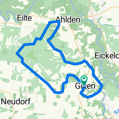
Suderbruch-Norddrebber
A cycling route starting in Gilten, Lower Saxony, Germany.
Overview
About this route
- 1 h 22 min
- Duration
- 20.9 km
- Distance
- 9 m
- Ascent
- 9 m
- Descent
- 15.3 km/h
- Avg. speed
- ---
- Max. altitude

Route quality
Waytypes & surfaces along the route
Waytypes
Quiet road
12.2 km
(58 %)
Road
3.7 km
(18 %)
Surfaces
Paved
16.1 km
(77 %)
Unpaved
0.2 km
(<1 %)
Asphalt
13.7 km
(66 %)
Concrete
0.9 km
(4 %)
Continue with Bikemap
Use, edit, or download this cycling route
You would like to ride Suderbruch-Norddrebber or customize it for your own trip? Here is what you can do with this Bikemap route:
Free features
- Save this route as favorite or in collections
- Copy & plan your own version of this route
- Sync your route with Garmin or Wahoo
Premium features
Free trial for 3 days, or one-time payment. More about Bikemap Premium.
- Navigate this route on iOS & Android
- Export a GPX / KML file of this route
- Create your custom printout (try it for free)
- Download this route for offline navigation
Discover more Premium features.
Get Bikemap PremiumFrom our community
Other popular routes starting in Gilten
 06:30 Uhr
- Distance
- 40.3 km
- Ascent
- 140 m
- Descent
- 138 m
- Location
- Gilten, Lower Saxony, Germany
 Die Wolfstour (Süd-Route)
- Distance
- 59.4 km
- Ascent
- 83 m
- Descent
- 82 m
- Location
- Gilten, Lower Saxony, Germany
 Suderbruch-Norddrebber
- Distance
- 20.9 km
- Ascent
- 9 m
- Descent
- 9 m
- Location
- Gilten, Lower Saxony, Germany
 Heidetour_2023v2
- Distance
- 18.9 km
- Ascent
- 73 m
- Descent
- 74 m
- Location
- Gilten, Lower Saxony, Germany
 Neudorf 21, Rodewald nach Neudorf 21, Rodewald
- Distance
- 21.6 km
- Ascent
- 142 m
- Descent
- 147 m
- Location
- Gilten, Lower Saxony, Germany
 Roundrip-Gilten1
- Distance
- 26.6 km
- Ascent
- 39 m
- Descent
- 41 m
- Location
- Gilten, Lower Saxony, Germany
 Gilten-Essel-RT1
- Distance
- 26.5 km
- Ascent
- 62 m
- Descent
- 62 m
- Location
- Gilten, Lower Saxony, Germany
 Gilten - Ahlden - Frankenfeldermühle
- Distance
- 13.4 km
- Ascent
- 36 m
- Descent
- 39 m
- Location
- Gilten, Lower Saxony, Germany
Open it in the app