

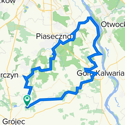
40 km Racibory - Czarnolas
A cycling route starting in Prażmów, Masovian Voivodeship, Poland.
Overview
About this route
Płaska treningowa trasa w ładnych plenerach.
- -:--
- Duration
- 40 km
- Distance
- 91 m
- Ascent
- 91 m
- Descent
- ---
- Avg. speed
- ---
- Max. altitude
Route quality
Waytypes & surfaces along the route
Waytypes
Road
22 km
(55 %)
Quiet road
4.4 km
(11 %)
Surfaces
Paved
34.8 km
(87 %)
Unpaved
2.4 km
(6 %)
Asphalt
34.8 km
(87 %)
Unpaved (undefined)
1.6 km
(4 %)
Continue with Bikemap
Use, edit, or download this cycling route
You would like to ride 40 km Racibory - Czarnolas or customize it for your own trip? Here is what you can do with this Bikemap route:
Free features
- Save this route as favorite or in collections
- Copy & plan your own version of this route
- Sync your route with Garmin or Wahoo
Premium features
Free trial for 3 days, or one-time payment. More about Bikemap Premium.
- Navigate this route on iOS & Android
- Export a GPX / KML file of this route
- Create your custom printout (try it for free)
- Download this route for offline navigation
Discover more Premium features.
Get Bikemap PremiumFrom our community
Other popular routes starting in Prażmów
 40 km Racibory - Czarnolas
- Distance
- 40 km
- Ascent
- 91 m
- Descent
- 91 m
- Location
- Prażmów, Masovian Voivodeship, Poland
 Racibory - Grójec -Białobrzegi - Warka
- Distance
- 108.4 km
- Ascent
- 214 m
- Descent
- 214 m
- Location
- Prażmów, Masovian Voivodeship, Poland
 Krótka runda
- Distance
- 27.8 km
- Ascent
- 108 m
- Descent
- 108 m
- Location
- Prażmów, Masovian Voivodeship, Poland
 Polna 4, Łoś do Polna 2, Łoś
- Distance
- 12.3 km
- Ascent
- 102 m
- Descent
- 101 m
- Location
- Prażmów, Masovian Voivodeship, Poland
 MILA i seta
- Distance
- 95 km
- Ascent
- 387 m
- Descent
- 388 m
- Location
- Prażmów, Masovian Voivodeship, Poland
 Wokół Tarczyna
- Distance
- 46 km
- Ascent
- 144 m
- Descent
- 143 m
- Location
- Prażmów, Masovian Voivodeship, Poland
 57km, Płaska
- Distance
- 56.7 km
- Ascent
- 96 m
- Descent
- 94 m
- Location
- Prażmów, Masovian Voivodeship, Poland
 90km, Racibory, Grójec, warka, Racibory.
- Distance
- 96.3 km
- Ascent
- 138 m
- Descent
- 140 m
- Location
- Prażmów, Masovian Voivodeship, Poland
Open it in the app