

Trainingstour um Tuttlingen
A cycling route starting in Immendingen, Baden-Wurttemberg, Germany.
Overview
About this route
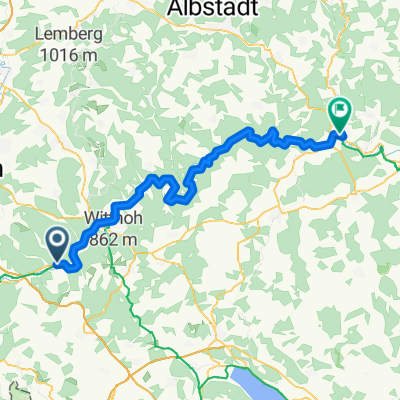
My training route around Tuttlingen. It starts with a long climb up to Mühlberg in Möhringen. After the wildlife enclosure, there's a long descent to the Tuttlingen outdoor pool. Following that, you ride completely through the city to reach the dog shelter, from where you go back uphill. Upon arriving at Lohhof, you pass by the Windegg restaurant, then back down into the valley to tackle the last steep ascent towards Hattingen. Through Hattingen and through the forest, you ride back to the starting point via the Möhringen ski slope along a long descent. The entire route takes about 1 to 1.5 hours depending on physical condition, and it's perfect for training endurance and strength.
- -:--
- Duration
- 27 km
- Distance
- 590 m
- Ascent
- 552 m
- Descent
- ---
- Avg. speed
- 877 m
- Max. altitude

Route quality
Waytypes & surfaces along the route
Waytypes
Track
11.1 km
(41 %)
Quiet road
6.5 km
(24 %)
Surfaces
Paved
15.6 km
(58 %)
Unpaved
7 km
(26 %)
Asphalt
11.9 km
(44 %)
Gravel
5.7 km
(21 %)
Continue with Bikemap
Use, edit, or download this cycling route
You would like to ride Trainingstour um Tuttlingen or customize it for your own trip? Here is what you can do with this Bikemap route:
Free features
- Save this route as favorite or in collections
- Copy & plan your own version of this route
- Sync your route with Garmin or Wahoo
Premium features
Free trial for 3 days, or one-time payment. More about Bikemap Premium.
- Navigate this route on iOS & Android
- Export a GPX / KML file of this route
- Create your custom printout (try it for free)
- Download this route for offline navigation
Discover more Premium features.
Get Bikemap PremiumFrom our community
Other popular routes starting in Immendingen
 Möhringen-Tuttlingen
- Distance
- 5.5 km
- Ascent
- 67 m
- Descent
- 89 m
- Location
- Immendingen, Baden-Wurttemberg, Germany
 Cousin-Trail / Armin & Jürgen
- Distance
- 56.5 km
- Ascent
- 1,040 m
- Descent
- 1,039 m
- Location
- Immendingen, Baden-Wurttemberg, Germany
 Immendingen- Öfingen- Geisingen- Immendingen
- Distance
- 30 km
- Ascent
- 282 m
- Descent
- 278 m
- Location
- Immendingen, Baden-Wurttemberg, Germany
 Rund um Möhringen
- Distance
- 34.7 km
- Ascent
- 657 m
- Descent
- 657 m
- Location
- Immendingen, Baden-Wurttemberg, Germany
 Trainingstour um Tuttlingen
- Distance
- 27 km
- Ascent
- 590 m
- Descent
- 552 m
- Location
- Immendingen, Baden-Wurttemberg, Germany
 Strecke MTB-Rennen Möhringen
- Distance
- 3.6 km
- Ascent
- 170 m
- Descent
- 170 m
- Location
- Immendingen, Baden-Wurttemberg, Germany
 Tour mit schönen Panorama
- Distance
- 59 km
- Ascent
- 673 m
- Descent
- 670 m
- Location
- Immendingen, Baden-Wurttemberg, Germany
 Donau-Radweg: Immendingen-Sigmaringen
- Distance
- 69 km
- Ascent
- 272 m
- Descent
- 369 m
- Location
- Immendingen, Baden-Wurttemberg, Germany
Open it in the app