

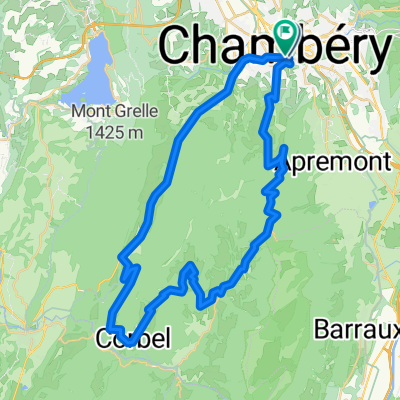
Chartreuse Alps 4 Col Loop
A cycling route starting in Chambéry, Auvergne-Rhône-Alpes, France.
Overview
About this route
- -:--
- Duration
- 56.7 km
- Distance
- 1,426 m
- Ascent
- 1,426 m
- Descent
- ---
- Avg. speed
- ---
- Max. altitude

Route quality
Waytypes & surfaces along the route
Waytypes
Road
26.6 km
(47 %)
Quiet road
2.3 km
(4 %)
Surfaces
Paved
43.1 km
(76 %)
Asphalt
43.1 km
(76 %)
Undefined
13.6 km
(24 %)
Route highlights
Points of interest along the route
Point of interest after 16.8 km
Col de Couz
Point of interest after 21.9 km
Col des Egaux
Point of interest after 29.7 km
Col de la Cluse
Point of interest after 41 km
Col du Granier
Continue with Bikemap
Use, edit, or download this cycling route
You would like to ride Chartreuse Alps 4 Col Loop or customize it for your own trip? Here is what you can do with this Bikemap route:
Free features
- Save this route as favorite or in collections
- Copy & plan your own version of this route
- Sync your route with Garmin or Wahoo
Premium features
Free trial for 3 days, or one-time payment. More about Bikemap Premium.
- Navigate this route on iOS & Android
- Export a GPX / KML file of this route
- Create your custom printout (try it for free)
- Download this route for offline navigation
Discover more Premium features.
Get Bikemap PremiumFrom our community
Other popular routes starting in Chambéry
 essais lapallud
- Distance
- 13 km
- Ascent
- 231 m
- Descent
- 25 m
- Location
- Chambéry, Auvergne-Rhône-Alpes, France
 A 01-04-CHAMBERY/GRENOBLE 64 KM
- Distance
- 62.7 km
- Ascent
- 130 m
- Descent
- 189 m
- Location
- Chambéry, Auvergne-Rhône-Alpes, France
 AZAZ
AZAZ- Distance
- 7.3 km
- Ascent
- 101 m
- Descent
- 129 m
- Location
- Chambéry, Auvergne-Rhône-Alpes, France
 ChamVildlCham 1/4bis
- Distance
- 107.1 km
- Ascent
- 3,648 m
- Descent
- 2,762 m
- Location
- Chambéry, Auvergne-Rhône-Alpes, France
 Chartreuse Alps loop via Col du Granier
- Distance
- 58.9 km
- Ascent
- 1,708 m
- Descent
- 1,550 m
- Location
- Chambéry, Auvergne-Rhône-Alpes, France
 ChamVildlCham 1/4ter
- Distance
- 127.9 km
- Ascent
- 5,077 m
- Descent
- 4,190 m
- Location
- Chambéry, Auvergne-Rhône-Alpes, France
 ESSAIS XXXXX
- Distance
- 16.1 km
- Ascent
- 188 m
- Descent
- 125 m
- Location
- Chambéry, Auvergne-Rhône-Alpes, France
 Circuit de Chartuese
- Distance
- 54 km
- Ascent
- 1,330 m
- Descent
- 1,330 m
- Location
- Chambéry, Auvergne-Rhône-Alpes, France
Open it in the app