

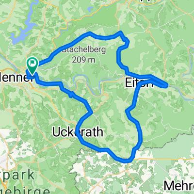
Hennef - Bröl - Tanneneck - Eitorf - Siegtal - Sieglinde - Hennef
A cycling route starting in Hennef, North Rhine-Westphalia, Germany.
Overview
About this route
Hinter Bröl kommt ein kontinuierlicher Anstieg. Ist aber sehr leicht. In Tanneneck geht es dann abwärts nach Eitorf. Zurück durchs Siegtal über Lauthausen zur Sieglinde. Lecker Bierchen und dann weiter nach Haus.
- -:--
- Duration
- 37.9 km
- Distance
- 391 m
- Ascent
- 391 m
- Descent
- ---
- Avg. speed
- ---
- Max. altitude
Route quality
Waytypes & surfaces along the route
Waytypes
Busy road
16.4 km
(43 %)
Road
8.2 km
(22 %)
Surfaces
Paved
34.1 km
(90 %)
Unpaved
0.5 km
(1 %)
Asphalt
33.8 km
(89 %)
Gravel
0.5 km
(1 %)
Continue with Bikemap
Use, edit, or download this cycling route
You would like to ride Hennef - Bröl - Tanneneck - Eitorf - Siegtal - Sieglinde - Hennef or customize it for your own trip? Here is what you can do with this Bikemap route:
Free features
- Save this route as favorite or in collections
- Copy & plan your own version of this route
- Sync your route with Garmin or Wahoo
Premium features
Free trial for 3 days, or one-time payment. More about Bikemap Premium.
- Navigate this route on iOS & Android
- Export a GPX / KML file of this route
- Create your custom printout (try it for free)
- Download this route for offline navigation
Discover more Premium features.
Get Bikemap PremiumFrom our community
Other popular routes starting in Hennef
 Wahnbachtalsperre
- Distance
- 57.7 km
- Ascent
- 215 m
- Descent
- 218 m
- Location
- Hennef, North Rhine-Westphalia, Germany
 Von Hennef (Sieg) bis Eitorf
- Distance
- 14.8 km
- Ascent
- 240 m
- Descent
- 167 m
- Location
- Hennef, North Rhine-Westphalia, Germany
 Siegtal - Linz am Rhein
- Distance
- 45.6 km
- Ascent
- 122 m
- Descent
- 130 m
- Location
- Hennef, North Rhine-Westphalia, Germany
 Rechts und Links der Sieg
- Distance
- 48.8 km
- Ascent
- 552 m
- Descent
- 454 m
- Location
- Hennef, North Rhine-Westphalia, Germany
 2025_1 Hennef bis Euskirchen
- Distance
- 65.7 km
- Ascent
- 346 m
- Descent
- 252 m
- Location
- Hennef, North Rhine-Westphalia, Germany
 wahnbachtlsperre
- Distance
- 5.7 km
- Ascent
- 147 m
- Descent
- 149 m
- Location
- Hennef, North Rhine-Westphalia, Germany
 Erlebnissweg Talsperrenweg
- Distance
- 23.6 km
- Ascent
- 455 m
- Descent
- 455 m
- Location
- Hennef, North Rhine-Westphalia, Germany
 Pfannkuchenmühlen-Route
- Distance
- 47.2 km
- Ascent
- 485 m
- Descent
- 494 m
- Location
- Hennef, North Rhine-Westphalia, Germany
Open it in the app