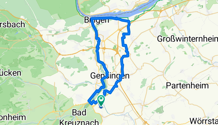
Recovered Route
A cycling route starting in Bretzenheim, Rhineland-Palatinate, Germany.
Overview
About this route
- 2 h 18 min
- Duration
- 42.5 km
- Distance
- 133 m
- Ascent
- 133 m
- Descent
- 18.5 km/h
- Avg. speed
- ---
- Max. altitude
Route quality
Waytypes & surfaces along the route
Waytypes
Track
22.9 km
(54 %)
Quiet road
6.8 km
(16 %)
Surfaces
Paved
35.7 km
(84 %)
Unpaved
2.5 km
(6 %)
Asphalt
27.2 km
(64 %)
Paved (undefined)
8.5 km
(20 %)
Continue with Bikemap
Use, edit, or download this cycling route
You would like to ride Recovered Route or customize it for your own trip? Here is what you can do with this Bikemap route:
Free features
- Save this route as favorite or in collections
- Copy & plan your own version of this route
- Sync your route with Garmin or Wahoo
Premium features
Free trial for 3 days, or one-time payment. More about Bikemap Premium.
- Navigate this route on iOS & Android
- Export a GPX / KML file of this route
- Create your custom printout (try it for free)
- Download this route for offline navigation
Discover more Premium features.
Get Bikemap PremiumFrom our community
Other popular routes starting in Bretzenheim
- Bad Kreuznach - Kirn Papiermühle
- Distance
- 46.4 km
- Ascent
- 260 m
- Descent
- 147 m
- Location
- Bretzenheim, Rhineland-Palatinate, Germany
- An der Kieskaute 19, Bad Kreuznach nach An der Kieskaute 19, Bad Kreuznach
- Distance
- 16.7 km
- Ascent
- 105 m
- Descent
- 107 m
- Location
- Bretzenheim, Rhineland-Palatinate, Germany
- Joggingroute 9,81 KM Planig, Bosenh., Hackenh., Volxh., Pleitersh.
- Distance
- 9.8 km
- Ascent
- 100 m
- Descent
- 60 m
- Location
- Bretzenheim, Rhineland-Palatinate, Germany
- Hargesheim Guldental MTB Strecke
- Distance
- 17 km
- Ascent
- 184 m
- Descent
- 185 m
- Location
- Bretzenheim, Rhineland-Palatinate, Germany
- Von der Nahe zum Rhein - 72 km Permanente des RC Michelin Bad Kreuznach e.V.
- Distance
- 78.5 km
- Ascent
- 724 m
- Descent
- 706 m
- Location
- Bretzenheim, Rhineland-Palatinate, Germany
- Rund um die Bockenauer Schweiz - 77 km Permanente des RC Michelin Bad Kreuznach e.V.
- Distance
- 77.7 km
- Ascent
- 1,121 m
- Descent
- 1,113 m
- Location
- Bretzenheim, Rhineland-Palatinate, Germany
- TD Bretzenheim/LaLo/Gensingen
- Distance
- 13.6 km
- Ascent
- 51 m
- Descent
- 49 m
- Location
- Bretzenheim, Rhineland-Palatinate, Germany
- Recovered Route
- Distance
- 42.5 km
- Ascent
- 133 m
- Descent
- 133 m
- Location
- Bretzenheim, Rhineland-Palatinate, Germany
Open it in the app