Wycieczka Nr 10/2013 – Suwalski Park Krajobrazowy- 05-09 czerwca
- 53.8 km
- 225 m
- 225 m
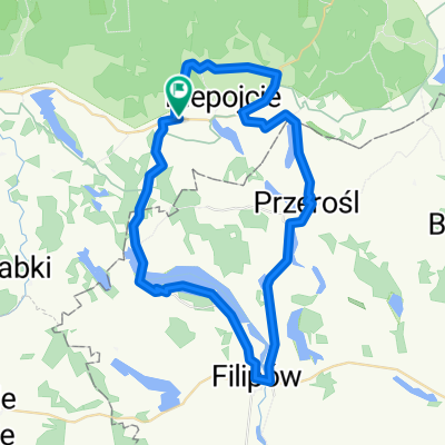
- Filipów, Podlasie Voivodship, Poland
A cycling route starting in Filipów, Podlasie Voivodship, Poland.
Overview
The route is short and the views are not particularly memorable. I only remember it because I got lost even though I was following a map ;) Unfortunately, there are so many field, gravel, and forest paths that it's easy to lose your way. That's why I mainly recommend it for mountain bikes or cross bikes. The route is flat and sometimes especially used by cars. I don't recommend taking your children on it due to the possibility of getting lost, which affects the child through loud reactions to our lack of orientation in the terrain and ultimately affects us, effectively depriving us of the pleasure of traveling ;)
created this 14 years ago
Route quality
Road
16.4 km
69 %
Quiet road
6.9 km
29 %
Undefined
0.5 km
2 %
Paved
17.8 km
(75 %)
Unpaved
5.7 km
(24 %)
Asphalt
17.1 km
72 %
Gravel
5.7 km
24 %
Continue with Bikemap
You would like to ride zagubiona Rospuda or customize it for your own trip? Here is what you can do with this Bikemap route:
Free trial for 3 days, or one-time payment. More about Bikemap Premium.
Discover more Premium features.
Get Bikemap PremiumFrom our community
Open it in the app