
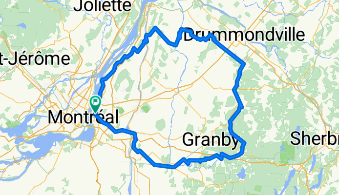
Boucle 310km 4jours
A cycling route starting in Longueuil, Quebec, Canada.
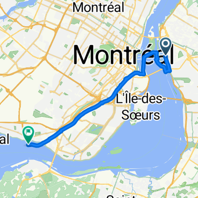
Overview
About this route
Camping: 37+37+33=107$+tx = 123$ Bouf:
- -:--
- Duration
- 310.2 km
- Distance
- 331 m
- Ascent
- 329 m
- Descent
- ---
- Avg. speed
- ---
- Max. altitude

Route quality
Waytypes & surfaces along the route
Waytypes
Road
114.8 km
(37 %)
Cycleway
114.8 km
(37 %)
Surfaces
Paved
195.4 km
(63 %)
Unpaved
74.4 km
(24 %)
Asphalt
170.6 km
(55 %)
Loose gravel
40.3 km
(13 %)
Route highlights
Points of interest along the route
Point of interest after 87.8 km
Camping Le Québécois 165 Rue Plessis, Massueville, QC J0G 1K0 +14507882680 33$+tx
Point of interest after 164.4 km
Camping de l'ile 238 Chemin Pépin, Roxton Falls, QC J0H 1E0 +14505482495 37$+tx
Point of interest after 227.3 km
Camping St-Alphonse 170 rue du Camping, Route 139, St-Alphonse de Granby +14503721440 37$/tx
Continue with Bikemap
Use, edit, or download this cycling route
You would like to ride Boucle 310km 4jours or customize it for your own trip? Here is what you can do with this Bikemap route:
Free features
- Save this route as favorite or in collections
- Copy & plan your own version of this route
- Split it into stages to create a multi-day tour
- Sync your route with Garmin or Wahoo
Premium features
Free trial for 3 days, or one-time payment. More about Bikemap Premium.
- Navigate this route on iOS & Android
- Export a GPX / KML file of this route
- Create your custom printout (try it for free)
- Download this route for offline navigation
Discover more Premium features.
Get Bikemap PremiumFrom our community
Other popular routes starting in Longueuil
 LBsecond
- Distance
- 22.6 km
- Ascent
- 31 m
- Descent
- 30 m
- Location
- Longueuil, Quebec, Canada
 Parc Canin - Parc des Ateliers
- Distance
- 18.2 km
- Ascent
- 6 m
- Descent
- 23 m
- Location
- Longueuil, Quebec, Canada
 Longueuil@Boucherville
- Distance
- 9.7 km
- Ascent
- 19 m
- Descent
- 23 m
- Location
- Longueuil, Quebec, Canada
 Exploration
- Distance
- 27.9 km
- Ascent
- 34 m
- Descent
- 32 m
- Location
- Longueuil, Quebec, Canada
 Candy Store Bike Route
- Distance
- 30 km
- Ascent
- 56 m
- Descent
- 43 m
- Location
- Longueuil, Quebec, Canada
 De Rue Henri-Deslongchamps à Rue Henri-Deslongchamps
- Distance
- 34.9 km
- Ascent
- 445 m
- Descent
- 421 m
- Location
- Longueuil, Quebec, Canada
 Île Notre-Dame - Canal Lachine
- Distance
- 22 km
- Ascent
- 57 m
- Descent
- 51 m
- Location
- Longueuil, Quebec, Canada
 Easy ride in Longueuil - parc enfants
- Distance
- 2.1 km
- Ascent
- 4 m
- Descent
- 0 m
- Location
- Longueuil, Quebec, Canada
Open it in the app