

Recovered Route
A cycling route starting in Valletta, Valletta, Malta.
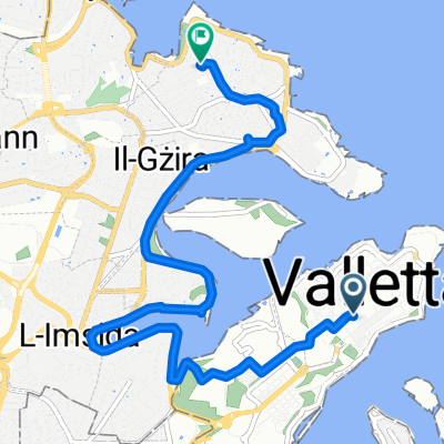
Overview
About this route
- 5 h 59 min
- Duration
- 200.9 km
- Distance
- 0 m
- Ascent
- 15 m
- Descent
- 33.6 km/h
- Avg. speed
- ---
- Max. altitude

Continue with Bikemap
Use, edit, or download this cycling route
You would like to ride Recovered Route or customize it for your own trip? Here is what you can do with this Bikemap route:
Free features
- Save this route as favorite or in collections
- Copy & plan your own version of this route
- Split it into stages to create a multi-day tour
- Sync your route with Garmin or Wahoo
Premium features
Free trial for 3 days, or one-time payment. More about Bikemap Premium.
- Navigate this route on iOS & Android
- Export a GPX / KML file of this route
- Create your custom printout (try it for free)
- Download this route for offline navigation
Discover more Premium features.
Get Bikemap PremiumFrom our community
Other popular routes starting in Valletta
 No Limit 32
- Distance
- 162 km
- Ascent
- 270 m
- Descent
- 303 m
- Location
- Valletta, Valletta, Malta
 Total Malta
- Distance
- 83.8 km
- Ascent
- 667 m
- Descent
- 682 m
- Location
- Valletta, Valletta, Malta
 01) crono Valletta
- Distance
- 14.2 km
- Ascent
- 164 m
- Descent
- 183 m
- Location
- Valletta, Valletta, Malta
 2 hour marsaxlott
- Distance
- 26.4 km
- Ascent
- 343 m
- Descent
- 365 m
- Location
- Valletta, Valletta, Malta
 De Triq San Ġwann, La Valeta a Triq Melita, Sliema
- Distance
- 7.6 km
- Ascent
- 7 m
- Descent
- 47 m
- Location
- Valletta, Valletta, Malta
 Steady ride in
- Distance
- 14.2 km
- Ascent
- 271 m
- Descent
- 285 m
- Location
- Valletta, Valletta, Malta
 Waterfront til birgu
- Distance
- 8.2 km
- Ascent
- 145 m
- Descent
- 156 m
- Location
- Valletta, Valletta, Malta
 01) crono Valletta
- Distance
- 14.2 km
- Ascent
- 180 m
- Descent
- 202 m
- Location
- Valletta, Valletta, Malta
Open it in the app