

Overview
About this route
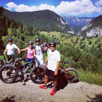
The bike tour to Sirnea is a wonderful experience for those who love nature and outdoor sports. With a length of approximately 18 km and a difference in elevation of 350 meters, the route is a perfect combination of relaxing rides and sporting challenges.
Starting from Sirnea, the route passes through picturesque forests, on slightly uneven and winding paths, offering a beautiful view of the area. Along the way, there are also places where you can take breaks to admire the scenery and enjoy the fresh air.
Due to the moderate elevation gain, the tour is accessible even for beginner cyclists, but still offers a sufficient sporting challenge for more advanced cyclists. Depending on the pedaling pace, the tour can be completed in about 3 hours, and throughout the course, impressive landscapes can be observed, such as the peaks of the mountains, forests, and rural areas.
In conclusion, the bike tour to Sirnea is a pleasant and memorable experience that offers a perfect combination of natural beauty and physical activity.
- -:--
- Duration
- 17.7 km
- Distance
- 392 m
- Ascent
- 395 m
- Descent
- ---
- Avg. speed
- 1,216 m
- Max. altitude

Part of
7 stages
Route photos


Route quality
Waytypes & surfaces along the route
Waytypes
Cycleway
6.5 km
(37 %)
Road
4.6 km
(26 %)
Surfaces
Paved
14.2 km
(80 %)
Unpaved
3.4 km
(19 %)
Asphalt
14.2 km
(80 %)
Gravel
2.7 km
(15 %)
Route highlights
Points of interest along the route

Point of interest after 6 km
Ursa Mica Glamping Resort
Continue with Bikemap
Use, edit, or download this cycling route
You would like to ride Tur Sirnea or customize it for your own trip? Here is what you can do with this Bikemap route:
Free features
- Save this route as favorite or in collections
- Copy & plan your own version of this route
- Sync your route with Garmin or Wahoo
Premium features
Free trial for 3 days, or one-time payment. More about Bikemap Premium.
- Navigate this route on iOS & Android
- Export a GPX / KML file of this route
- Create your custom printout (try it for free)
- Download this route for offline navigation
Discover more Premium features.
Get Bikemap PremiumFrom our community
Other popular routes starting in Moeciu de Jos
 Peștera (Nobilis) - Măgura - Moieciu de Jos (Hanul cu Noroc)
- Distance
- 11.9 km
- Ascent
- 93 m
- Descent
- 493 m
- Location
- Moeciu de Jos, Brașov County, Romania
 propunere 2 moeciu-sosea-sirnea-pestera
- Distance
- 25.6 km
- Ascent
- 698 m
- Descent
- 696 m
- Location
- Moeciu de Jos, Brașov County, Romania
 Pestera - PrapastiileZarnestilor (sub Grindu)
- Distance
- 19.6 km
- Ascent
- 776 m
- Descent
- 680 m
- Location
- Moeciu de Jos, Brașov County, Romania
 Moieciu Jos - Amfiteatru Transilvania - Moieciu Sus - Cheile Gradistei - Fundata - Fundatica - Moieciu Sus - Moieciu Jos
- Distance
- 36.1 km
- Ascent
- 1,092 m
- Descent
- 1,091 m
- Location
- Moeciu de Jos, Brașov County, Romania
 V3 Antrenament: Moeciu - Saua Batrana - Saua Strunga - Moeciu
- Distance
- 41.6 km
- Ascent
- 1,520 m
- Descent
- 1,520 m
- Location
- Moeciu de Jos, Brașov County, Romania
 Tur Cheile Dambovicioarei
- Distance
- 42.8 km
- Ascent
- 902 m
- Descent
- 902 m
- Location
- Moeciu de Jos, Brașov County, Romania
 All4MTB - Piatra Craiului - nivel mediu
- Distance
- 22.9 km
- Ascent
- 967 m
- Descent
- 967 m
- Location
- Moeciu de Jos, Brașov County, Romania
 All4MTB - Piatra Craiului - nivel mediu
- Distance
- 22.8 km
- Ascent
- 962 m
- Descent
- 962 m
- Location
- Moeciu de Jos, Brașov County, Romania
Open it in the app