
180 km Památky a gastronomie Blatná, Žinkovy, pivovar Letiny "silniční Borec"
A cycling route starting in Třemošná, Plzeň Region, Czechia.
Overview
About this route
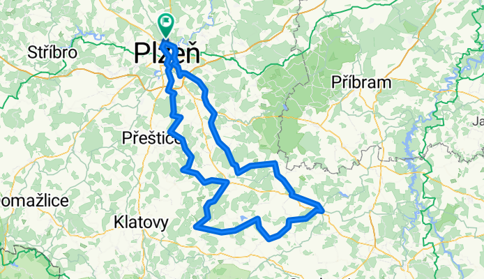
Route description: Borec is a medium-length route running along very nice roads with light traffic. It takes us to the southern border of the Plzeň Region, and at the control points you'll pass by Blatná Castle and the Green Hill. The route can be ridden in both directions, but we recommend riding clockwise. After the start, turn left, then continue towards the Bolevec Pond. Control points - photo signs marking start/end of towns:
- Dožice
- Blatná
- Plánice
- Nepomuk
- Letiny
Difficulty: The route consists of 90% smooth, high-quality asphalt and 10% less quality but very rideable sections.
- -:--
- Duration
- 180.8 km
- Distance
- 1,780 m
- Ascent
- 1,780 m
- Descent
- ---
- Avg. speed
- ---
- Max. altitude

Route quality
Waytypes & surfaces along the route
Waytypes
Road
65.1 km
(36 %)
Cycleway
16.3 km
(9 %)
Surfaces
Paved
68.7 km
(38 %)
Asphalt
63.3 km
(35 %)
Paved (undefined)
5.4 km
(3 %)
Undefined
112.1 km
(62 %)
Continue with Bikemap
Use, edit, or download this cycling route
You would like to ride 180 km Památky a gastronomie Blatná, Žinkovy, pivovar Letiny "silniční Borec" or customize it for your own trip? Here is what you can do with this Bikemap route:
Free features
- Save this route as favorite or in collections
- Copy & plan your own version of this route
- Split it into stages to create a multi-day tour
- Sync your route with Garmin or Wahoo
Premium features
Free trial for 3 days, or one-time payment. More about Bikemap Premium.
- Navigate this route on iOS & Android
- Export a GPX / KML file of this route
- Create your custom printout (try it for free)
- Download this route for offline navigation
Discover more Premium features.
Get Bikemap PremiumFrom our community
Other popular routes starting in Třemošná
 2013-04-29-ke Chlumu
- Distance
- 26.4 km
- Ascent
- 264 m
- Descent
- 261 m
- Location
- Třemošná, Plzeň Region, Czechia
 Sidlovak – Chotikov – Malesicka skala – Radcice –Sylvan – Sidlovak
- Distance
- 14.6 km
- Ascent
- 203 m
- Descent
- 207 m
- Location
- Třemošná, Plzeň Region, Czechia
 100 km Údolím Berounky "MTB Sporťák"
- Distance
- 101.2 km
- Ascent
- 2,004 m
- Descent
- 2,004 m
- Location
- Třemošná, Plzeň Region, Czechia
 Plzeň - Plasy a zpět
- Distance
- 49.1 km
- Ascent
- 522 m
- Descent
- 517 m
- Location
- Třemošná, Plzeň Region, Czechia
 180 km Památky a gastronomie Blatná, Žinkovy, pivovar Letiny "silniční Borec"
- Distance
- 180.8 km
- Ascent
- 1,780 m
- Descent
- 1,780 m
- Location
- Třemošná, Plzeň Region, Czechia
 Od ranče ke dvěma plzeňským rozhlednám
- Distance
- 32.3 km
- Ascent
- 308 m
- Descent
- 235 m
- Location
- Třemošná, Plzeň Region, Czechia
 Středa 28.6
- Distance
- 23 km
- Ascent
- 204 m
- Descent
- 179 m
- Location
- Třemošná, Plzeň Region, Czechia
 140 km Okolo Plzně
- Distance
- 140.8 km
- Ascent
- 800 m
- Descent
- 799 m
- Location
- Třemošná, Plzeň Region, Czechia
Open it in the app