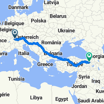
der Grabentrail
A cycling route starting in Altendorf, Canton of Schwyz, Switzerland.
Overview
About this route
aufsteig haubstsächlich auf asphalt und zeitweise sehr steil.
Â
der single trail ist am anfang ein schöner wald weg der gegen ende hin ein loser schotterweg wird.
Â
augen auf > es hat ein paar weg gablungen der jeder sein reiz hat ;)
- -:--
- Duration
- 13.4 km
- Distance
- 710 m
- Ascent
- 606 m
- Descent
- ---
- Avg. speed
- 1,028 m
- Avg. speed
Route quality
Waytypes & surfaces along the route
Waytypes
Quiet road
6.9 km
(52 %)
Track
4.8 km
(36 %)
Surfaces
Paved
3.4 km
(25 %)
Unpaved
4.6 km
(34 %)
Asphalt
3.2 km
(24 %)
Gravel
3 km
(22 %)
Route highlights
Points of interest along the route
Point of interest after 8.8 km
einstieg trail in der kehre
Point of interest after 9.8 km
viel wege fĂĽrn nach Rom ;)
Point of interest after 10.8 km
beim strommasten wieder rein in den kurzen trail
Continue with Bikemap
Use, edit, or download this cycling route
You would like to ride der Grabentrail or customize it for your own trip? Here is what you can do with this Bikemap route:
Free features
- Save this route as favorite or in collections
- Copy & plan your own version of this route
- Sync your route with Garmin or Wahoo
Premium features
Free trial for 3 days, or one-time payment. More about Bikemap Premium.
- Navigate this route on iOS & Android
- Export a GPX / KML file of this route
- Create your custom printout (try it for free)
- Download this route for offline navigation
Discover more Premium features.
Get Bikemap PremiumFrom our community
Other popular routes starting in Altendorf
- Lange Ausfahrt von Altendorf nach Lachen SZ
- Distance
- 31.7 km
- Ascent
- 1,161 m
- Descent
- 1,177 m
- Location
- Altendorf, Canton of Schwyz, Switzerland
- Lachen-Sattelegg
- Distance
- 30.1 km
- Ascent
- 1,018 m
- Descent
- 1,017 m
- Location
- Altendorf, Canton of Schwyz, Switzerland
- der Grabentrail
- Distance
- 13.4 km
- Ascent
- 710 m
- Descent
- 606 m
- Location
- Altendorf, Canton of Schwyz, Switzerland
- Lachen - Ruchweid - Willerzell - Etzel - Pfäffike
- Distance
- 34.8 km
- Ascent
- 1,028 m
- Descent
- 1,023 m
- Location
- Altendorf, Canton of Schwyz, Switzerland
- Sattelegg for newbies
- Distance
- 64 km
- Ascent
- 1,099 m
- Descent
- 978 m
- Location
- Altendorf, Canton of Schwyz, Switzerland
- Alpen 2012 - Pragelpass
- Distance
- 110.6 km
- Ascent
- 1,682 m
- Descent
- 1,682 m
- Location
- Altendorf, Canton of Schwyz, Switzerland
- #nichtganzzweihundert2025
- Distance
- 203.7 km
- Ascent
- 2,993 m
- Descent
- 2,989 m
- Location
- Altendorf, Canton of Schwyz, Switzerland
- Lange Ausfahrt durch Altendorf
- Distance
- 55.9 km
- Ascent
- 1,934 m
- Descent
- 1,934 m
- Location
- Altendorf, Canton of Schwyz, Switzerland