

Spelga Hilarys
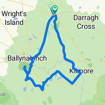
A cycling route starting in Saintfield, Northern Ireland, United Kingdom.
Overview
About this route
- -:--
- Duration
- 107.2 km
- Distance
- 1,650 m
- Ascent
- 1,649 m
- Descent
- ---
- Avg. speed
- ---
- Max. altitude

Route quality
Waytypes & surfaces along the route
Waytypes
Quiet road
42.9 km
(40 %)
Road
30 km
(28 %)
Undefined
34.3 km
(32 %)
Surfaces
Paved
96.5 km
(90 %)
Asphalt
96.5 km
(90 %)
Undefined
10.7 km
(10 %)
Continue with Bikemap
Use, edit, or download this cycling route
You would like to ride Spelga Hilarys or customize it for your own trip? Here is what you can do with this Bikemap route:
Free features
- Save this route as favorite or in collections
- Copy & plan your own version of this route
- Split it into stages to create a multi-day tour
- Sync your route with Garmin or Wahoo
Premium features
Free trial for 3 days, or one-time payment. More about Bikemap Premium.
- Navigate this route on iOS & Android
- Export a GPX / KML file of this route
- Create your custom printout (try it for free)
- Download this route for offline navigation
Discover more Premium features.
Get Bikemap PremiumFrom our community
Other popular routes starting in Saintfield
 Spelga Hilarys
- Distance
- 107.2 km
- Ascent
- 1,650 m
- Descent
- 1,649 m
- Location
- Saintfield, Northern Ireland, United Kingdom
 Tim and I round Colinglen
- Distance
- 75 km
- Ascent
- 778 m
- Descent
- 820 m
- Location
- Saintfield, Northern Ireland, United Kingdom
 Route in Ballynahinch
- Distance
- 37.1 km
- Ascent
- 388 m
- Descent
- 389 m
- Location
- Saintfield, Northern Ireland, United Kingdom
Open it in the app