
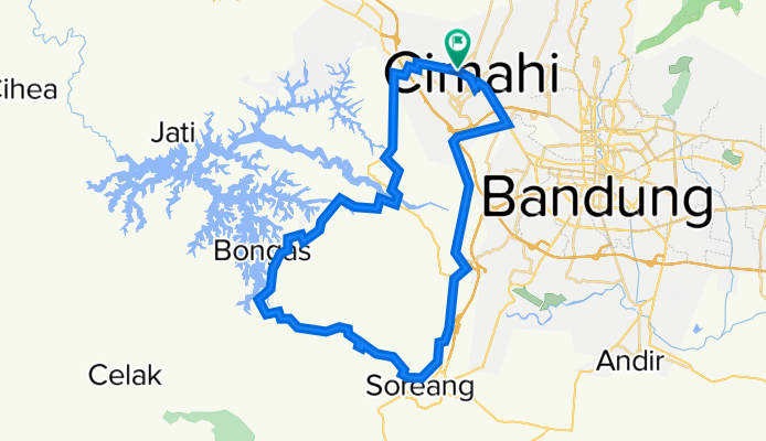
Cimahi - Puncak Mulya - Soreang - Cimahi
A cycling route starting in Cimahi, West Java, Indonesia.
Overview
About this route
Trip tak diduga, yang rencananya mau offroad di Tangkuban Parahu dsk malah belok ke sini. Dan jadilah panas-panasan di tanjakan jalan aspal yang begitu melelahkan karena memang saya belum siap mungkin ya melaui jalur ini ;-)
Walaupun melelahkan tapi cukup mengasyikan, apalagi pemandangannya yang jarang ditemukan di tempat lain. Dan yang pasti kebersamaanya itu yang selalu terkenang.. Thank's
- -:--
- Duration
- 62.4 km
- Distance
- 554 m
- Ascent
- 553 m
- Descent
- ---
- Avg. speed
- ---
- Max. altitude

Continue with Bikemap
Use, edit, or download this cycling route
You would like to ride Cimahi - Puncak Mulya - Soreang - Cimahi or customize it for your own trip? Here is what you can do with this Bikemap route:
Free features
- Save this route as favorite or in collections
- Copy & plan your own version of this route
- Sync your route with Garmin or Wahoo
Premium features
Free trial for 3 days, or one-time payment. More about Bikemap Premium.
- Navigate this route on iOS & Android
- Export a GPX / KML file of this route
- Create your custom printout (try it for free)
- Download this route for offline navigation
Discover more Premium features.
Get Bikemap PremiumFrom our community
Other popular routes starting in Cimahi
 Jalan Sukimun, Kecamatan Cimahi Tengah to Jalan Sukimun, Kecamatan Cimahi Tengah
- Distance
- 34.1 km
- Ascent
- 289 m
- Descent
- 289 m
- Location
- Cimahi, West Java, Indonesia
 Jl. Meleber – Rahayu, Margaasih.
- Distance
- 6.7 km
- Ascent
- 0 m
- Descent
- 56 m
- Location
- Cimahi, West Java, Indonesia
 Restful route
- Distance
- 13.7 km
- Ascent
- 47 m
- Descent
- 68 m
- Location
- Cimahi, West Java, Indonesia
 Maribaya Lembang Cisarua
- Distance
- 45.8 km
- Ascent
- 762 m
- Descent
- 762 m
- Location
- Cimahi, West Java, Indonesia
 Pesantren - Kota Baru Parahyangan
- Distance
- 21.7 km
- Ascent
- 610 m
- Descent
- 646 m
- Location
- Cimahi, West Java, Indonesia
 Bdg-Lembang-Gn.Kasur-U.Berung-Bdg
- Distance
- 56 km
- Ascent
- 1,080 m
- Descent
- 1,080 m
- Location
- Cimahi, West Java, Indonesia
 Batujajar - Tangkuban Parahu via Cihanjuang
- Distance
- 36.8 km
- Ascent
- 1,237 m
- Descent
- 412 m
- Location
- Cimahi, West Java, Indonesia
 Cimahi-Ciuyah-Cisarua-Situ Lembang
- Distance
- 15.6 km
- Ascent
- 816 m
- Descent
- 31 m
- Location
- Cimahi, West Java, Indonesia
Open it in the app