

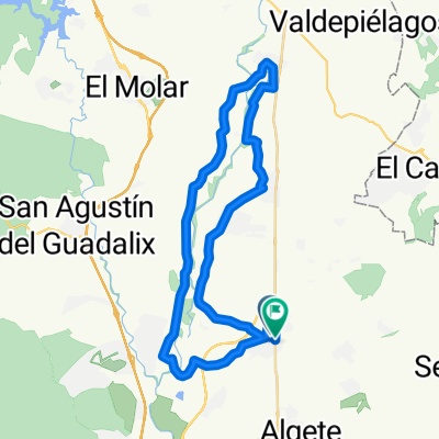
Ciudalcampo-El Espartal-Ciudalcampo
A cycling route starting in Fuente el Saz, Madrid, Spain.
Overview
About this route
Test ride, round trip, to explore the banks of the Jarama and thus connect San Agustín with the area of Algete and others. For cyclists.
- -:--
- Duration
- 20.6 km
- Distance
- 115 m
- Ascent
- 64 m
- Descent
- ---
- Avg. speed
- ---
- Max. altitude

Route quality
Waytypes & surfaces along the route
Waytypes
Track
16.1 km
(78 %)
Quiet road
3.7 km
(18 %)
Access road
0.8 km
(4 %)
Surfaces
Paved
4.7 km
(23 %)
Unpaved
8 km
(39 %)
Ground
8 km
(39 %)
Paved (undefined)
4.7 km
(23 %)
Undefined
7.8 km
(38 %)
Continue with Bikemap
Use, edit, or download this cycling route
You would like to ride Ciudalcampo-El Espartal-Ciudalcampo or customize it for your own trip? Here is what you can do with this Bikemap route:
Free features
- Save this route as favorite or in collections
- Copy & plan your own version of this route
- Sync your route with Garmin or Wahoo
Premium features
Free trial for 3 days, or one-time payment. More about Bikemap Premium.
- Navigate this route on iOS & Android
- Export a GPX / KML file of this route
- Create your custom printout (try it for free)
- Download this route for offline navigation
Discover more Premium features.
Get Bikemap PremiumFrom our community
Other popular routes starting in Fuente el Saz
 Ciudalcampo-El Espartal-Ciudalcampo
- Distance
- 20.6 km
- Ascent
- 115 m
- Descent
- 64 m
- Location
- Fuente el Saz, Madrid, Spain
 Urb. Club de Campo-Valdetorres-Alalpardo 09.12.12
- Distance
- 36.3 km
- Ascent
- 89 m
- Descent
- 88 m
- Location
- Fuente el Saz, Madrid, Spain
 ETAPA 21 Circuito del Jarama - Estadio Santiago Bernabeu 145KM
- Distance
- 145.7 km
- Ascent
- 849 m
- Descent
- 747 m
- Location
- Fuente el Saz, Madrid, Spain
 fuente el saz 86k
- Distance
- 84.7 km
- Ascent
- 664 m
- Descent
- 665 m
- Location
- Fuente el Saz, Madrid, Spain
 Club de Campo - Pte Marmota- Pte Grajal- Pte Batán- Manzanares el Real
- Distance
- 48.6 km
- Ascent
- 842 m
- Descent
- 544 m
- Location
- Fuente el Saz, Madrid, Spain
 Club de Campo - Pte Grajal- Pte Batán- Manzanares el Real
- Distance
- 44.3 km
- Ascent
- 616 m
- Descent
- 317 m
- Location
- Fuente el Saz, Madrid, Spain
 Ruta a Calle Almendralejos
- Distance
- 43 km
- Ascent
- 153 m
- Descent
- 198 m
- Location
- Fuente el Saz, Madrid, Spain
 Urb. Ciudalcampo; Riberas del Jarama 26.09.15
- Distance
- 27.8 km
- Ascent
- 48 m
- Descent
- 51 m
- Location
- Fuente el Saz, Madrid, Spain
Open it in the app