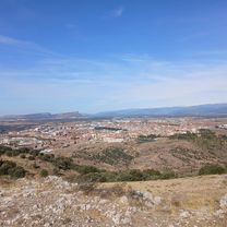
Soria, rábanos por sendas (no la muy difícil), los royales, caballo blanco, soria
A cycling route starting in Soria, Castille and León, Spain.
Overview
About this route
Hora Inicio: 18:27 15 abr. 2021 Hora Fin: 20:57 15 abr. 2021 Distancia recorrida: 21,1 km (02:29) Tiempo en movimiento: 01:47 Velocidad media: 8,46 km/h Vel. en Mov.: 11,81 km/h Velocidad Máxima: 44,18 km/h Altura Mínima: 1001 m Altura Máxima: 1119 m Velocidad Ascenso: 616,1 m/h Velocidad Descenso: 357,1 m/h Ganancia Altitud: 530 m Pérdida Altitud: 527 m Tiempo Ascenso: 00:51 Tiempo Descenso: 01:28
- 2 h 30 min
- Duration
- 21.1 km
- Distance
- 558 m
- Ascent
- 566 m
- Descent
- 8.5 km/h
- Avg. speed
- ---
- Avg. speed
Continue with Bikemap
Use, edit, or download this cycling route
You would like to ride Soria, rábanos por sendas (no la muy difícil), los royales, caballo blanco, soria or customize it for your own trip? Here is what you can do with this Bikemap route:
Free features
- Save this route as favorite or in collections
- Copy & plan your own version of this route
- Sync your route with Garmin or Wahoo
Premium features
Free trial for 3 days, or one-time payment. More about Bikemap Premium.
- Navigate this route on iOS & Android
- Export a GPX / KML file of this route
- Create your custom printout (try it for free)
- Download this route for offline navigation
Discover more Premium features.
Get Bikemap PremiumFrom our community
Other popular routes starting in Soria
- 1995 - 1 SORIA - PIQUERAS - LAGUNA NEGRA
- Distance
- 146.3 km
- Ascent
- 1,908 m
- Descent
- 1,915 m
- Location
- Soria, Castille and León, Spain
- Soria - El Moncalvillo
- Distance
- 223.8 km
- Ascent
- 3,364 m
- Descent
- 2,967 m
- Location
- Soria, Castille and León, Spain
- Soria-Quintana-Matamala-Almazán-Cubo Solana-Tardajos-Ribarrolla-Aldealafuente-Alconaba-Soria
- Distance
- 100.3 km
- Ascent
- 445 m
- Descent
- 460 m
- Location
- Soria, Castille and León, Spain
- Vuelta al Valle - Almajano
- Distance
- 79.9 km
- Ascent
- 543 m
- Descent
- 544 m
- Location
- Soria, Castille and León, Spain
- 1995 - 2 SORIA - CARGADERO VINUESA
- Distance
- 132.6 km
- Ascent
- 703 m
- Descent
- 702 m
- Location
- Soria, Castille and León, Spain
- Soria-Pto.Piqueras-Villos.Cameros-Pto.Sta.Ines-LagunaNegra-Cidones-Soria
- Distance
- 144.9 km
- Ascent
- 1,944 m
- Descent
- 1,911 m
- Location
- Soria, Castille and León, Spain
- Soria, rábanos por sendas (no la muy difícil), los royales, caballo blanco, soria
- Distance
- 21.1 km
- Ascent
- 558 m
- Descent
- 566 m
- Location
- Soria, Castille and León, Spain
- 1995 - 1ª etapa soria - piqueras - cameros - vinuesa - soria
- Distance
- 146.4 km
- Ascent
- 2,030 m
- Descent
- 2,031 m
- Location
- Soria, Castille and León, Spain
Open it in the app