

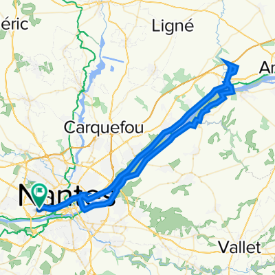
De Chantenay à Challans
A cycling route starting in Bouguenais, Pays de la Loire Region, France.
Overview
About this route
From Chantenay to Challans via Machecoul
- -:--
- Duration
- 57.7 km
- Distance
- 140 m
- Ascent
- 177 m
- Descent
- ---
- Avg. speed
- ---
- Max. altitude

Route quality
Waytypes & surfaces along the route
Waytypes
Road
39.3 km
(68 %)
Quiet road
8.7 km
(15 %)
Surfaces
Paved
13.3 km
(23 %)
Unpaved
0.6 km
(1 %)
Asphalt
13.3 km
(23 %)
Gravel
0.6 km
(1 %)
Undefined
43.9 km
(76 %)
Continue with Bikemap
Use, edit, or download this cycling route
You would like to ride De Chantenay à Challans or customize it for your own trip? Here is what you can do with this Bikemap route:
Free features
- Save this route as favorite or in collections
- Copy & plan your own version of this route
- Sync your route with Garmin or Wahoo
Premium features
Free trial for 3 days, or one-time payment. More about Bikemap Premium.
- Navigate this route on iOS & Android
- Export a GPX / KML file of this route
- Create your custom printout (try it for free)
- Download this route for offline navigation
Discover more Premium features.
Get Bikemap PremiumFrom our community
Other popular routes starting in Bouguenais
 R.T 2
R.T 2- Distance
- 9,825.5 km
- Ascent
- 3,807 m
- Descent
- 2,189 m
- Location
- Bouguenais, Pays de la Loire Region, France
 Pélerinage à la Bimboire
- Distance
- 74.9 km
- Ascent
- 317 m
- Descent
- 316 m
- Location
- Bouguenais, Pays de la Loire Region, France
 Loire 2021
- Distance
- 796.6 km
- Ascent
- 3,825 m
- Descent
- 3,650 m
- Location
- Bouguenais, Pays de la Loire Region, France
 BRETAGNA RIKY
- Distance
- 947.7 km
- Ascent
- 922 m
- Descent
- 920 m
- Location
- Bouguenais, Pays de la Loire Region, France
 Nantes-Basel
- Distance
- 895.3 km
- Ascent
- 4,469 m
- Descent
- 4,227 m
- Location
- Bouguenais, Pays de la Loire Region, France
 De 2–26 Rue des Sapins, Bouguenais à 2 Chemin de l'Auvelon, Bouaye
- Distance
- 6.9 km
- Ascent
- 39 m
- Descent
- 33 m
- Location
- Bouguenais, Pays de la Loire Region, France
 aeroporto - ostello
- Distance
- 10.8 km
- Ascent
- 38 m
- Descent
- 57 m
- Location
- Bouguenais, Pays de la Loire Region, France
 Bouguenais
- Distance
- 41.8 km
- Ascent
- 221 m
- Descent
- 219 m
- Location
- Bouguenais, Pays de la Loire Region, France
Open it in the app