
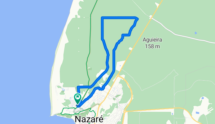
Nazaré
A cycling route starting in Nazaré, Leiria District, Portugal.
Overview
About this route
From Rua Joaquim Rodrigues Granada 3, 2450-503 Nazaré, Centro, Portugal To Rua Joaquim Rodrigues Granada 3, 2450-503 Nazaré, Centro, Portugal
Routing Hiking - most beautiful
- -:--
- Duration
- 9.3 km
- Distance
- 130 m
- Ascent
- 128 m
- Descent
- ---
- Avg. speed
- ---
- Max. altitude

Route quality
Waytypes & surfaces along the route
Waytypes
Track
6.2 km
(67 %)
Quiet road
2.2 km
(24 %)
Surfaces
Paved
2 km
(22 %)
Unpaved
5.7 km
(61 %)
Gravel
1.9 km
(20 %)
Asphalt
1.8 km
(19 %)
Continue with Bikemap
Use, edit, or download this cycling route
You would like to ride Nazaré or customize it for your own trip? Here is what you can do with this Bikemap route:
Free features
- Save this route as favorite or in collections
- Copy & plan your own version of this route
- Sync your route with Garmin or Wahoo
Premium features
Free trial for 3 days, or one-time payment. More about Bikemap Premium.
- Navigate this route on iOS & Android
- Export a GPX / KML file of this route
- Create your custom printout (try it for free)
- Download this route for offline navigation
Discover more Premium features.
Get Bikemap PremiumFrom our community
Other popular routes starting in Nazaré
 Nazare - Serra da Pescaria
- Distance
- 14 km
- Ascent
- 341 m
- Descent
- 342 m
- Location
- Nazaré, Leiria District, Portugal
 De Rua D 15, Nazaré a Portugal, Nazaré
- Distance
- 19.3 km
- Ascent
- 277 m
- Descent
- 299 m
- Location
- Nazaré, Leiria District, Portugal
 Domingo 23/05/2021
- Distance
- 11 km
- Ascent
- 203 m
- Descent
- 140 m
- Location
- Nazaré, Leiria District, Portugal
 De Rua Sub-Vila 71, Nazaré a Portugal, Nazaré
- Distance
- 35.5 km
- Ascent
- 442 m
- Descent
- 442 m
- Location
- Nazaré, Leiria District, Portugal
 13 may. Nazare-Alcobaca-Mira de aire caves - camping
- Distance
- 62.3 km
- Ascent
- 573 m
- Descent
- 642 m
- Location
- Nazaré, Leiria District, Portugal
 Nazaré - Golega
- Distance
- 74.8 km
- Ascent
- 805 m
- Descent
- 890 m
- Location
- Nazaré, Leiria District, Portugal
 Praia do Salgado
- Distance
- 18 km
- Ascent
- 448 m
- Descent
- 357 m
- Location
- Nazaré, Leiria District, Portugal
 De Rua Sub-Vila 71, Nazaré a Rua Sub-Vila 71, Nazaré
- Distance
- 54.3 km
- Ascent
- 443 m
- Descent
- 442 m
- Location
- Nazaré, Leiria District, Portugal
Open it in the app