

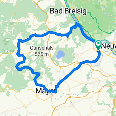
Schrumpfbachtal - 73 km Permanente des Rad Club Albatros 1924 e.V. Andernach
A cycling route starting in Andernach, Rhineland-Palatinate, Germany.
Overview
About this route
Schrumpfbachtal - 73 km
Permanente RTF des Rad Club Albatros 1924 e.V. Andernach
Alle weiteren Hinweise zu dieser Strecke -> hier anklicken
- -:--
- Duration
- 68.9 km
- Distance
- 525 m
- Ascent
- 525 m
- Descent
- ---
- Avg. speed
- ---
- Max. altitude

Route quality
Waytypes & surfaces along the route
Waytypes
Busy road
41.2 km
(60 %)
Path
8.8 km
(13 %)
Surfaces
Paved
59.1 km
(86 %)
Unpaved
3.8 km
(6 %)
Asphalt
57 km
(83 %)
Gravel
3.5 km
(5 %)
Route highlights
Points of interest along the route
Point of interest after 25.7 km
Kontrolle <b>Löf</b><br>ARAL Tankstelle
Continue with Bikemap
Use, edit, or download this cycling route
You would like to ride Schrumpfbachtal - 73 km Permanente des Rad Club Albatros 1924 e.V. Andernach or customize it for your own trip? Here is what you can do with this Bikemap route:
Free features
- Save this route as favorite or in collections
- Copy & plan your own version of this route
- Sync your route with Garmin or Wahoo
Premium features
Free trial for 3 days, or one-time payment. More about Bikemap Premium.
- Navigate this route on iOS & Android
- Export a GPX / KML file of this route
- Create your custom printout (try it for free)
- Download this route for offline navigation
Discover more Premium features.
Get Bikemap PremiumFrom our community
Other popular routes starting in Andernach
 Rund um Andernach 2011 - RTF des Rad Club Albatros 1924 e.V. Andernach - 73 km Strecke
- Distance
- 72 km
- Ascent
- 416 m
- Descent
- 416 m
- Location
- Andernach, Rhineland-Palatinate, Germany
 Andernach - Koblenz25km - (Lahnmündung+8km) - Andernach
- Distance
- 65.8 km
- Ascent
- 33 m
- Descent
- 34 m
- Location
- Andernach, Rhineland-Palatinate, Germany
 Andernach bis Köln
- Distance
- 79.5 km
- Ascent
- 300 m
- Descent
- 316 m
- Location
- Andernach, Rhineland-Palatinate, Germany
 2016 - 5. Tag
- Distance
- 102.9 km
- Ascent
- 125 m
- Descent
- 145 m
- Location
- Andernach, Rhineland-Palatinate, Germany
 Andernach-Kruft-Nette
- Distance
- 35.6 km
- Ascent
- 334 m
- Descent
- 259 m
- Location
- Andernach, Rhineland-Palatinate, Germany
 Nettetal 2013 - 75 km Permanente des Rad Club Albatros 1924 e.V. Andernach
- Distance
- 72.5 km
- Ascent
- 560 m
- Descent
- 560 m
- Location
- Andernach, Rhineland-Palatinate, Germany
 Kirchstraße 33, Andernach nach Uferstraße 5, Andernach
- Distance
- 46.8 km
- Ascent
- 351 m
- Descent
- 364 m
- Location
- Andernach, Rhineland-Palatinate, Germany
 Antel 121, Andernach nach Heerstraße 43–47, Sankt Goar
- Distance
- 64.6 km
- Ascent
- 358 m
- Descent
- 422 m
- Location
- Andernach, Rhineland-Palatinate, Germany
Open it in the app