

Vrapče, Risnjak, Vrapče
A cycling route starting in Stenjevec, City of Zagreb, Croatia.
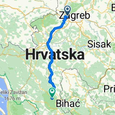
Overview
About this route
- 2 h 46 min
- Duration
- 29.7 km
- Distance
- 874 m
- Ascent
- 919 m
- Descent
- 10.8 km/h
- Avg. speed
- ---
- Max. altitude

Route photos


Continue with Bikemap
Use, edit, or download this cycling route
You would like to ride Vrapče, Risnjak, Vrapče or customize it for your own trip? Here is what you can do with this Bikemap route:
Free features
- Save this route as favorite or in collections
- Copy & plan your own version of this route
- Sync your route with Garmin or Wahoo
Premium features
Free trial for 3 days, or one-time payment. More about Bikemap Premium.
- Navigate this route on iOS & Android
- Export a GPX / KML file of this route
- Create your custom printout (try it for free)
- Download this route for offline navigation
Discover more Premium features.
Get Bikemap PremiumFrom our community
Other popular routes starting in Stenjevec
 Zagreb - Samobor - Kotari - Samobor - Zagreb
- Distance
- 69.3 km
- Ascent
- 550 m
- Descent
- 550 m
- Location
- Stenjevec, City of Zagreb, Croatia
 Stojdraga
- Distance
- 121.5 km
- Ascent
- 907 m
- Descent
- 897 m
- Location
- Stenjevec, City of Zagreb, Croatia
 baks-soldo
- Distance
- 45.2 km
- Ascent
- 76 m
- Descent
- 64 m
- Location
- Stenjevec, City of Zagreb, Croatia
 BBK rotor kustosija-vrapce
- Distance
- 25.2 km
- Ascent
- 880 m
- Descent
- 906 m
- Location
- Stenjevec, City of Zagreb, Croatia
 Zagreb - Plitvica
- Distance
- 135 km
- Ascent
- 924 m
- Descent
- 440 m
- Location
- Stenjevec, City of Zagreb, Croatia
 Sljeme - staza 5
- Distance
- 5 km
- Ascent
- 490 m
- Descent
- 73 m
- Location
- Stenjevec, City of Zagreb, Croatia
 Jarun Smb Galgovo Hudi Bitek Jarun
- Distance
- 82.6 km
- Ascent
- 427 m
- Descent
- 427 m
- Location
- Stenjevec, City of Zagreb, Croatia
 vuglec breg
- Distance
- 99.4 km
- Ascent
- 964 m
- Descent
- 964 m
- Location
- Stenjevec, City of Zagreb, Croatia
Open it in the app