

über den Bodanrück
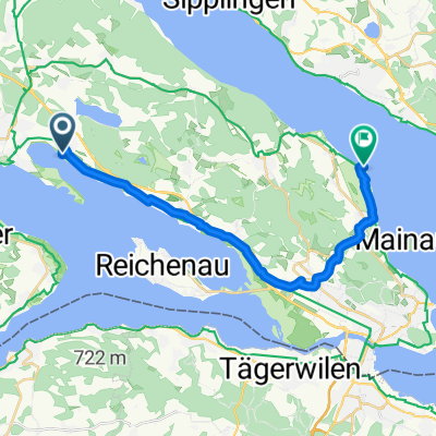
A cycling route starting in Radolfzell, Baden-Wurttemberg, Germany.
Overview
About this route
over Staringen up the Dettelbach to Liggeringen, further to Dettingen and back over Kaltbrunn and Markelfingen
- -:--
- Duration
- 37.6 km
- Distance
- 294 m
- Ascent
- 296 m
- Descent
- ---
- Avg. speed
- ---
- Max. altitude

Continue with Bikemap
Use, edit, or download this cycling route
You would like to ride über den Bodanrück or customize it for your own trip? Here is what you can do with this Bikemap route:
Free features
- Save this route as favorite or in collections
- Copy & plan your own version of this route
- Sync your route with Garmin or Wahoo
Premium features
Free trial for 3 days, or one-time payment. More about Bikemap Premium.
- Navigate this route on iOS & Android
- Export a GPX / KML file of this route
- Create your custom printout (try it for free)
- Download this route for offline navigation
Discover more Premium features.
Get Bikemap PremiumFrom our community
Other popular routes starting in Radolfzell
 über den Bodanrück
- Distance
- 37.6 km
- Ascent
- 294 m
- Descent
- 296 m
- Location
- Radolfzell, Baden-Wurttemberg, Germany
 Nordendstraße, Radolfzell am Bodensee nach Nordendstraße, Radolfzell am Bodensee
- Distance
- 37.2 km
- Ascent
- 685 m
- Descent
- 685 m
- Location
- Radolfzell, Baden-Wurttemberg, Germany
 Kleine Hegau Tour........
- Distance
- 87.6 km
- Ascent
- 772 m
- Descent
- 716 m
- Location
- Radolfzell, Baden-Wurttemberg, Germany
 Unterer Bodensee Umrundung
- Distance
- 71.3 km
- Ascent
- 160 m
- Descent
- 162 m
- Location
- Radolfzell, Baden-Wurttemberg, Germany
 allensbach
- Distance
- 22.9 km
- Ascent
- 140 m
- Descent
- 140 m
- Location
- Radolfzell, Baden-Wurttemberg, Germany
 D3: Radolfzell - Konstanz
- Distance
- 20.6 km
- Ascent
- 121 m
- Descent
- 114 m
- Location
- Radolfzell, Baden-Wurttemberg, Germany
 Nach Bodman durchs Echotal
- Distance
- 30.9 km
- Ascent
- 558 m
- Descent
- 558 m
- Location
- Radolfzell, Baden-Wurttemberg, Germany
 Drei Seen Route
- Distance
- 27.5 km
- Ascent
- 484 m
- Descent
- 484 m
- Location
- Radolfzell, Baden-Wurttemberg, Germany
Open it in the app