

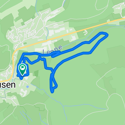
Rothaarsteig-Spur Oberhundemer Bergtour
A cycling route starting in Kirchhundem, North Rhine-Westphalia, Germany.
Overview
About this route
Rolling forests with magnificent views, rugged rocks, and fascinating panoramic views at Kahleberg are complemented on this tour by adventurous path sections on old donkey trails. A stop at the Alpenhaus (rest days: Tuesday, Wednesday) after two-thirds of the route crowns this enormously scenic Rothaarsteig extra tour.
- 2 h 7 min
- Duration
- 11.6 km
- Distance
- 419 m
- Ascent
- 419 m
- Descent
- 5.5 km/h
- Avg. speed
- ---
- Max. altitude
Route quality
Waytypes & surfaces along the route
Waytypes
Track
8.1 km
(70 %)
Path
2.7 km
(23 %)
Surfaces
Paved
1 km
(9 %)
Unpaved
10.3 km
(89 %)
Gravel
7.8 km
(67 %)
Unpaved (undefined)
1.4 km
(12 %)
Continue with Bikemap
Use, edit, or download this cycling route
You would like to ride Rothaarsteig-Spur Oberhundemer Bergtour or customize it for your own trip? Here is what you can do with this Bikemap route:
Free features
- Save this route as favorite or in collections
- Copy & plan your own version of this route
- Sync your route with Garmin or Wahoo
Premium features
Free trial for 3 days, or one-time payment. More about Bikemap Premium.
- Navigate this route on iOS & Android
- Export a GPX / KML file of this route
- Create your custom printout (try it for free)
- Download this route for offline navigation
Discover more Premium features.
Get Bikemap PremiumFrom our community
Other popular routes starting in Kirchhundem
 2.Tag Saalhausen-Winterberg
- Distance
- 40.6 km
- Ascent
- 823 m
- Descent
- 480 m
- Location
- Kirchhundem, North Rhine-Westphalia, Germany
 Kurze Ausfahrt durch Lennestadt
- Distance
- 9.1 km
- Ascent
- 226 m
- Descent
- 231 m
- Location
- Kirchhundem, North Rhine-Westphalia, Germany
 waldrunde mittel
- Distance
- 5 km
- Ascent
- 262 m
- Descent
- 262 m
- Location
- Kirchhundem, North Rhine-Westphalia, Germany
 Schmallenberg1
- Distance
- 34.6 km
- Ascent
- 588 m
- Descent
- 584 m
- Location
- Kirchhundem, North Rhine-Westphalia, Germany
 Rundfahrt zum Drachenfest auf dem Franzosenkopf
- Distance
- 63.4 km
- Ascent
- 733 m
- Descent
- 786 m
- Location
- Kirchhundem, North Rhine-Westphalia, Germany
 MTB Bundesliegastrecke Saalhausen CLONED FROM ROUTE 1107955
- Distance
- 4.1 km
- Ascent
- 219 m
- Descent
- 219 m
- Location
- Kirchhundem, North Rhine-Westphalia, Germany
 Brachthausen-Ahe-Flape
- Distance
- 20.2 km
- Ascent
- 486 m
- Descent
- 484 m
- Location
- Kirchhundem, North Rhine-Westphalia, Germany
 Kirchhundemer Land 1
- Distance
- 21.3 km
- Ascent
- 316 m
- Descent
- 281 m
- Location
- Kirchhundem, North Rhine-Westphalia, Germany
Open it in the app