

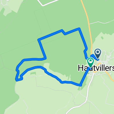
Champagne II
A cycling route starting in Dizy, Grand Est, France.
Overview
About this route
- -:--
- Duration
- 61.7 km
- Distance
- 730 m
- Ascent
- 732 m
- Descent
- ---
- Avg. speed
- ---
- Max. altitude
Route quality
Waytypes & surfaces along the route
Waytypes
Road
32.7 km
(53 %)
Quiet road
21 km
(34 %)
Surfaces
Paved
46.3 km
(75 %)
Asphalt
46.3 km
(75 %)
Undefined
15.4 km
(25 %)
Continue with Bikemap
Use, edit, or download this cycling route
You would like to ride Champagne II or customize it for your own trip? Here is what you can do with this Bikemap route:
Free features
- Save this route as favorite or in collections
- Copy & plan your own version of this route
- Sync your route with Garmin or Wahoo
Premium features
Free trial for 3 days, or one-time payment. More about Bikemap Premium.
- Navigate this route on iOS & Android
- Export a GPX / KML file of this route
- Create your custom printout (try it for free)
- Download this route for offline navigation
Discover more Premium features.
Get Bikemap PremiumFrom our community
Other popular routes starting in Dizy
 12345
12345- Distance
- 1.2 km
- Ascent
- 0 m
- Descent
- 0 m
- Location
- Dizy, Grand Est, France
![[Trek] V 52 - La véloroute de la Marne](https://media.bikemap.net/routes/9775768/staticmaps/in_6fe7cd34-87dc-4960-9d1b-26e368a8f1eb_400x400_bikemap-2021-3D-static.png) [Trek] V 52 - La véloroute de la Marne
[Trek] V 52 - La véloroute de la Marne- Distance
- 22.8 km
- Ascent
- 25 m
- Descent
- 18 m
- Location
- Dizy, Grand Est, France
 Champagne II
- Distance
- 61.7 km
- Ascent
- 730 m
- Descent
- 732 m
- Location
- Dizy, Grand Est, France
 St imoges tur retur
- Distance
- 37.9 km
- Ascent
- 504 m
- Descent
- 506 m
- Location
- Dizy, Grand Est, France
 Écluse de Dizy, Hautvillers nach 260 Rue de Dizy, Cumières
- Distance
- 0.5 km
- Ascent
- 0 m
- Descent
- 0 m
- Location
- Dizy, Grand Est, France
 Paris - Straßburg Tag 3
- Distance
- 95.9 km
- Ascent
- 64 m
- Descent
- 0 m
- Location
- Dizy, Grand Est, France
 Route in Hautvillers
- Distance
- 5.4 km
- Ascent
- 151 m
- Descent
- 151 m
- Location
- Dizy, Grand Est, France
 Dizy - Sarry
- Distance
- 42.9 km
- Ascent
- 36 m
- Descent
- 22 m
- Location
- Dizy, Grand Est, France
Open it in the app