

Ruta de andrey
A cycling route starting in North York, Ontario, Canada.
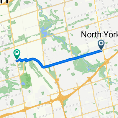
Overview
About this route
- 1 h 40 min
- Duration
- 25 km
- Distance
- 195 m
- Ascent
- 295 m
- Descent
- 14.9 km/h
- Avg. speed
- ---
- Max. altitude

Continue with Bikemap
Use, edit, or download this cycling route
You would like to ride Ruta de andrey or customize it for your own trip? Here is what you can do with this Bikemap route:
Free features
- Save this route as favorite or in collections
- Copy & plan your own version of this route
- Sync your route with Garmin or Wahoo
Premium features
Free trial for 3 days, or one-time payment. More about Bikemap Premium.
- Navigate this route on iOS & Android
- Export a GPX / KML file of this route
- Create your custom printout (try it for free)
- Download this route for offline navigation
Discover more Premium features.
Get Bikemap PremiumFrom our community
Other popular routes starting in North York
 Downsview park to Evelyn Tennis Courts
- Distance
- 27.8 km
- Ascent
- 147 m
- Descent
- 232 m
- Location
- North York, Ontario, Canada
 43.735, -79.444 to 43.675, -79.407
- Distance
- 50.8 km
- Ascent
- 283 m
- Descent
- 345 m
- Location
- North York, Ontario, Canada
 Yonge St, Toronto to Keele St, Toronto
- Distance
- 7.2 km
- Ascent
- 47 m
- Descent
- 33 m
- Location
- North York, Ontario, Canada
 First Bike ride
- Distance
- 8.2 km
- Ascent
- 40 m
- Descent
- 37 m
- Location
- North York, Ontario, Canada
 Connaught Ave to Earl Bales Park
- Distance
- 18.7 km
- Ascent
- 109 m
- Descent
- 109 m
- Location
- North York, Ontario, Canada
 Out of the City
- Distance
- 22.9 km
- Ascent
- 79 m
- Descent
- 59 m
- Location
- North York, Ontario, Canada
 Reiner Rd, Toronto to Reiner Rd, Toronto
- Distance
- 82 km
- Ascent
- 594 m
- Descent
- 592 m
- Location
- North York, Ontario, Canada
 Southgate Ave, Toronto to University Ave, Toronto
- Distance
- 16.2 km
- Ascent
- 47 m
- Descent
- 130 m
- Location
- North York, Ontario, Canada
Open it in the app