

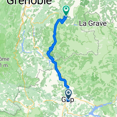
**08-S. Gap - Col d'Izoard (156,5 Km)
A cycling route starting in Gap, Provence-Alpes-Côte d'Azur Region, France.
Overview
About this route
Sisteron >>> Gap
- -:--
- Duration
- 156.4 km
- Distance
- 4,771 m
- Ascent
- 3,150 m
- Descent
- ---
- Avg. speed
- 2,362 m
- Max. altitude
Route quality
Waytypes & surfaces along the route
Waytypes
Quiet road
7.8 km
(5 %)
Path
7.8 km
(5 %)
Surfaces
Paved
100.1 km
(64 %)
Unpaved
1.6 km
(1 %)
Asphalt
100.1 km
(64 %)
Gravel
1.6 km
(1 %)
Undefined
54.7 km
(35 %)
Route highlights
Points of interest along the route
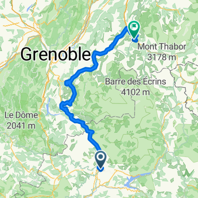
Point of interest after 24.9 km
COL Lebraut (3) Km 23,7 · 1.110 m
Point of interest after 50.6 km
CÔTE de Saint-Vincent-les-Forts (3) Km 49 · 1.142 m
Point of interest after 79 km
SPRINT Barcelonette Km. 76
Point of interest after 109.6 km
COL de Vars (1) Km. 106,8 · 2.110 m
Point of interest after 156.4 km
COL d'Izoard (HC) Km. 156,3 · 2360 m
Continue with Bikemap
Use, edit, or download this cycling route
You would like to ride **08-S. Gap - Col d'Izoard (156,5 Km) or customize it for your own trip? Here is what you can do with this Bikemap route:
Free features
- Save this route as favorite or in collections
- Copy & plan your own version of this route
- Split it into stages to create a multi-day tour
- Sync your route with Garmin or Wahoo
Premium features
Free trial for 3 days, or one-time payment. More about Bikemap Premium.
- Navigate this route on iOS & Android
- Export a GPX / KML file of this route
- Create your custom printout (try it for free)
- Download this route for offline navigation
Discover more Premium features.
Get Bikemap PremiumFrom our community
Other popular routes starting in Gap
 France : Gap - Romans-sur-Isère
- Distance
- 171.9 km
- Ascent
- 827 m
- Descent
- 1,412 m
- Location
- Gap, Provence-Alpes-Côte d'Azur Region, France
 *13-V. Gap - Briançon (156,5 Km)
- Distance
- 156.5 km
- Ascent
- 3,826 m
- Descent
- 3,293 m
- Location
- Gap, Provence-Alpes-Côte d'Azur Region, France
 montcolombis
- Distance
- 89.8 km
- Ascent
- 2,278 m
- Descent
- 2,276 m
- Location
- Gap, Provence-Alpes-Côte d'Azur Region, France
 BRM 200 Km Gap - 12 Avril 14
- Distance
- 203.8 km
- Ascent
- 1,657 m
- Descent
- 1,657 m
- Location
- Gap, Provence-Alpes-Côte d'Azur Region, France
 2026: 19. Gap - Alpe d'Huez
- Distance
- 109 km
- Ascent
- 5,010 m
- Descent
- 3,938 m
- Location
- Gap, Provence-Alpes-Côte d'Azur Region, France
 La batie - Rambaud - Trechatel
- Distance
- 18.3 km
- Ascent
- 309 m
- Descent
- 309 m
- Location
- Gap, Provence-Alpes-Côte d'Azur Region, France
 Tour de France 2015 - Stage 18
- Distance
- 190.3 km
- Ascent
- 3,252 m
- Descent
- 3,447 m
- Location
- Gap, Provence-Alpes-Côte d'Azur Region, France
 2016 Ride Day 86 - Gap to Jansac
- Distance
- 83.5 km
- Ascent
- 923 m
- Descent
- 975 m
- Location
- Gap, Provence-Alpes-Côte d'Azur Region, France
Open it in the app