

TA15 5
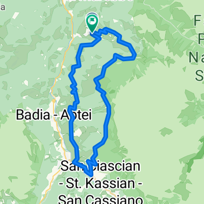
A cycling route starting in San Genesio, Trentino-Alto Adige, Italy.
Overview
About this route
- -:--
- Duration
- 131.3 km
- Distance
- 6,236 m
- Ascent
- 6,913 m
- Descent
- ---
- Avg. speed
- ---
- Max. altitude

Route quality
Waytypes & surfaces along the route
Waytypes
Track
65.7 km
(50 %)
Path
21 km
(16 %)
Surfaces
Paved
22.3 km
(17 %)
Unpaved
85.3 km
(65 %)
Gravel
42 km
(32 %)
Unpaved (undefined)
30.2 km
(23 %)
Route highlights
Points of interest along the route
Accommodation after 0 km
Pederühütte
Accommodation after 5.8 km
Fanes Hütte
Accommodation after 23.8 km
Pralongia Hütte
Accommodation after 30.9 km
Arabba
Point of interest after 34 km
Alternative Route
Point of interest after 41.6 km
MTB S2 Glühweintrail
Point of interest after 48.4 km
Rif Salei
Point of interest after 51.3 km
Brixen
Point of interest after 131.2 km
Bruneck
Continue with Bikemap
Use, edit, or download this cycling route
You would like to ride TA15 5 or customize it for your own trip? Here is what you can do with this Bikemap route:
Free features
- Save this route as favorite or in collections
- Copy & plan your own version of this route
- Split it into stages to create a multi-day tour
- Sync your route with Garmin or Wahoo
Premium features
Free trial for 3 days, or one-time payment. More about Bikemap Premium.
- Navigate this route on iOS & Android
- Export a GPX / KML file of this route
- Create your custom printout (try it for free)
- Download this route for offline navigation
Discover more Premium features.
Get Bikemap PremiumFrom our community
Other popular routes starting in San Genesio
 Fanes-Senes Runde
- Distance
- 45.3 km
- Ascent
- 2,428 m
- Descent
- 2,196 m
- Location
- San Genesio, Trentino-Alto Adige, Italy
 TA15 5
- Distance
- 131.3 km
- Ascent
- 6,236 m
- Descent
- 6,913 m
- Location
- San Genesio, Trentino-Alto Adige, Italy
 Pederu-riscone ritorno
- Distance
- 31.3 km
- Ascent
- 419 m
- Descent
- 1,037 m
- Location
- San Genesio, Trentino-Alto Adige, Italy
 Fanes Hütte - Aschau i. Zillertal
- Distance
- 152.1 km
- Ascent
- 1,572 m
- Descent
- 3,063 m
- Location
- San Genesio, Trentino-Alto Adige, Italy
 Fanes-Sennes-Runde
- Distance
- 31.2 km
- Ascent
- 1,524 m
- Descent
- 1,523 m
- Location
- San Genesio, Trentino-Alto Adige, Italy
 gunter 5
- Distance
- 41.2 km
- Ascent
- 1,861 m
- Descent
- 1,881 m
- Location
- San Genesio, Trentino-Alto Adige, Italy
 La Val - Wengen - La Valle - Taéla - Dlijia da la Crusc - Heiligkreuz-Hospitz
- Distance
- 30.6 km
- Ascent
- 1,135 m
- Descent
- 1,137 m
- Location
- San Genesio, Trentino-Alto Adige, Italy
 Fannes Sennes Gais
- Distance
- 74.7 km
- Ascent
- 1,651 m
- Descent
- 2,241 m
- Location
- San Genesio, Trentino-Alto Adige, Italy
Open it in the app