

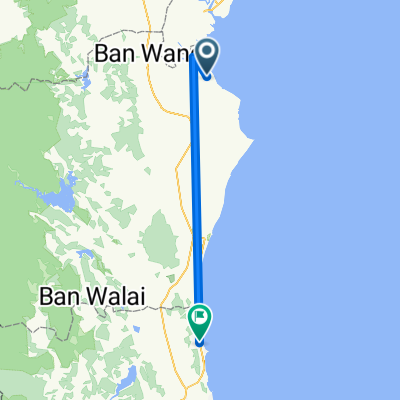
BaanLaem to HadChao
A cycling route starting in Ban Laem, Phetchaburi, Thailand.
Overview
About this route
- 1 h 44 min
- Duration
- 31.1 km
- Distance
- 47 m
- Ascent
- 46 m
- Descent
- 17.9 km/h
- Avg. speed
- ---
- Max. altitude

Route quality
Waytypes & surfaces along the route
Waytypes
Busy road
21.7 km
(70 %)
Quiet road
5.4 km
(17 %)
Surfaces
Paved
25.8 km
(83 %)
Unpaved
0.5 km
(1 %)
Asphalt
20.4 km
(66 %)
Paved (undefined)
5.4 km
(18 %)
Continue with Bikemap
Use, edit, or download this cycling route
You would like to ride BaanLaem to HadChao or customize it for your own trip? Here is what you can do with this Bikemap route:
Free features
- Save this route as favorite or in collections
- Copy & plan your own version of this route
- Sync your route with Garmin or Wahoo
Premium features
Free trial for 3 days, or one-time payment. More about Bikemap Premium.
- Navigate this route on iOS & Android
- Export a GPX / KML file of this route
- Create your custom printout (try it for free)
- Download this route for offline navigation
Discover more Premium features.
Get Bikemap PremiumFrom our community
Other popular routes starting in Ban Laem
 Thailand to Phet Kasem Road
- Distance
- 88.3 km
- Ascent
- 36 m
- Descent
- 4 m
- Location
- Ban Laem, Phetchaburi, Thailand
 วันที่ 2 บางตะบูน - หัวหิน
- Distance
- 95.8 km
- Ascent
- 110 m
- Descent
- 109 m
- Location
- Ban Laem, Phetchaburi, Thailand
 Klue Wan Coffee to Had Chao
- Distance
- 22.3 km
- Ascent
- 35 m
- Descent
- 29 m
- Location
- Ban Laem, Phetchaburi, Thailand
 samut songkhram-phuket airport
- Distance
- 781.3 km
- Ascent
- 440 m
- Descent
- 433 m
- Location
- Ban Laem, Phetchaburi, Thailand
 BaanLaem to HadChao
- Distance
- 31.1 km
- Ascent
- 47 m
- Descent
- 46 m
- Location
- Ban Laem, Phetchaburi, Thailand
 4028, Tambon Bang Khunsai to 4028, Tambon Bang Kaeo
- Distance
- 12 km
- Ascent
- 31 m
- Descent
- 32 m
- Location
- Ban Laem, Phetchaburi, Thailand
 Bang Tabon-Kanchanaburi
- Distance
- 152.4 km
- Ascent
- 46 m
- Descent
- 17 m
- Location
- Ban Laem, Phetchaburi, Thailand
 Homestay Cha-am
- Distance
- 64.4 km
- Ascent
- 63 m
- Descent
- 60 m
- Location
- Ban Laem, Phetchaburi, Thailand
Open it in the app