

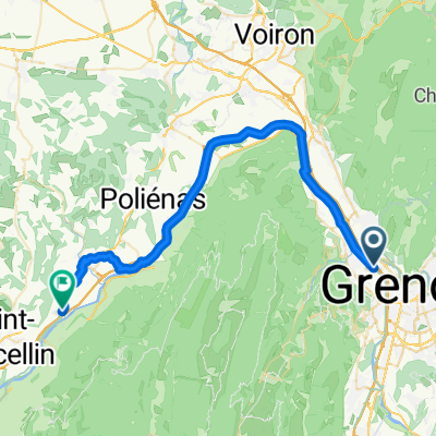
petites roches
A cycling route starting in Fontaine, Auvergne-Rhône-Alpes, France.
Overview
About this route
Fontaine St Vincent via the small rocks
- -:--
- Duration
- 53 km
- Distance
- 1,004 m
- Ascent
- 883 m
- Descent
- ---
- Avg. speed
- ---
- Max. altitude
Route quality
Waytypes & surfaces along the route
Waytypes
Road
18 km
(34 %)
Cycleway
9 km
(17 %)
Surfaces
Paved
39.8 km
(75 %)
Unpaved
0.5 km
(1 %)
Asphalt
39.2 km
(74 %)
Concrete
0.5 km
(1 %)
Continue with Bikemap
Use, edit, or download this cycling route
You would like to ride petites roches or customize it for your own trip? Here is what you can do with this Bikemap route:
Free features
- Save this route as favorite or in collections
- Copy & plan your own version of this route
- Sync your route with Garmin or Wahoo
Premium features
Free trial for 3 days, or one-time payment. More about Bikemap Premium.
- Navigate this route on iOS & Android
- Export a GPX / KML file of this route
- Create your custom printout (try it for free)
- Download this route for offline navigation
Discover more Premium features.
Get Bikemap PremiumFrom our community
Other popular routes starting in Fontaine
 Cognin le Gorge - Grenoble 80km
- Distance
- 42.9 km
- Ascent
- 149 m
- Descent
- 131 m
- Location
- Fontaine, Auvergne-Rhône-Alpes, France
 Grenoble à Chemin de la Châtaigneraie, Vaulnaveys-le-Bas
- Distance
- 31.4 km
- Ascent
- 892 m
- Descent
- 759 m
- Location
- Fontaine, Auvergne-Rhône-Alpes, France
 day001
- Distance
- 51.9 km
- Ascent
- 1,353 m
- Descent
- 829 m
- Location
- Fontaine, Auvergne-Rhône-Alpes, France
 les chemins de traverse
- Distance
- 6.7 km
- Ascent
- 34 m
- Descent
- 40 m
- Location
- Fontaine, Auvergne-Rhône-Alpes, France
 tag eins
- Distance
- 68.2 km
- Ascent
- 1,110 m
- Descent
- 1,106 m
- Location
- Fontaine, Auvergne-Rhône-Alpes, France
 La communauté de l'anneau
- Distance
- 4.9 km
- Ascent
- 43 m
- Descent
- 27 m
- Location
- Fontaine, Auvergne-Rhône-Alpes, France
 Vierter Tag
- Distance
- 92 km
- Ascent
- 1,230 m
- Descent
- 1,225 m
- Location
- Fontaine, Auvergne-Rhône-Alpes, France
 Traversée Chartreuse - Retour lac d'aiguebelette par Mont du Chat
- Distance
- 174.5 km
- Ascent
- 3,295 m
- Descent
- 3,298 m
- Location
- Fontaine, Auvergne-Rhône-Alpes, France
Open it in the app