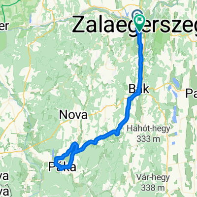
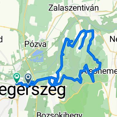
Őrség-Alpokalja 1. nap
A cycling route starting in Zalaegerszeg, Zala County, Hungary.
Overview
About this route
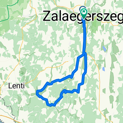
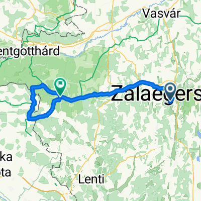
Zalaegerszeg - Zalalövő - Vadása Lake
- -:--
- Duration
- 31.3 km
- Distance
- 115 m
- Ascent
- 43 m
- Descent
- ---
- Avg. speed
- ---
- Max. altitude
Route quality
Waytypes & surfaces along the route
Waytypes
Cycleway
19.4 km
(62 %)
Quiet road
3.1 km
(10 %)
Surfaces
Paved
29.7 km
(95 %)
Unpaved
0.6 km
(2 %)
Asphalt
29.7 km
(95 %)
Ground
0.6 km
(2 %)
Undefined
0.9 km
(3 %)
Continue with Bikemap
Use, edit, or download this cycling route
You would like to ride Őrség-Alpokalja 1. nap or customize it for your own trip? Here is what you can do with this Bikemap route:
Free features
- Save this route as favorite or in collections
- Copy & plan your own version of this route
- Sync your route with Garmin or Wahoo
Premium features
Free trial for 3 days, or one-time payment. More about Bikemap Premium.
- Navigate this route on iOS & Android
- Export a GPX / KML file of this route
- Create your custom printout (try it for free)
- Download this route for offline navigation
Discover more Premium features.
Get Bikemap PremiumFrom our community
Other popular routes starting in Zalaegerszeg
Zalaegerszeg - Bajánsenye- Distance
- 59.6 km
- Ascent
- 298 m
- Descent
- 230 m
- Location
- Zalaegerszeg, Zala County, Hungary
Zalaegerszeg - Gornja Radgona- Distance
- 88.4 km
- Ascent
- 566 m
- Descent
- 497 m
- Location
- Zalaegerszeg, Zala County, Hungary
Mikes Kelemen utca, Zalaegerszeg - Dózsa György utca, Zalaegerszeg- Distance
- 61.5 km
- Ascent
- 283 m
- Descent
- 282 m
- Location
- Zalaegerszeg, Zala County, Hungary
Boncodfölde - Rákóczi utca- Distance
- 19.4 km
- Ascent
- 143 m
- Descent
- 163 m
- Location
- Zalaegerszeg, Zala County, Hungary
Őrségi kör- Distance
- 85.5 km
- Ascent
- 312 m
- Descent
- 312 m
- Location
- Zalaegerszeg, Zala County, Hungary
rét utca - rét utca- Distance
- 130.3 km
- Ascent
- 604 m
- Descent
- 656 m
- Location
- Zalaegerszeg, Zala County, Hungary
Vizslaparki út, Zalaegerszeg - Zrínyi Miklós utca, Zalaegerszeg- Distance
- 83 km
- Ascent
- 353 m
- Descent
- 350 m
- Location
- Zalaegerszeg, Zala County, Hungary
Kossuth Lajos utca, Petrikeresztúr - Kossuth Lajos utca, Petrikeresztúr- Distance
- 13.2 km
- Ascent
- 323 m
- Descent
- 323 m
- Location
- Zalaegerszeg, Zala County, Hungary
Open it in the app


