

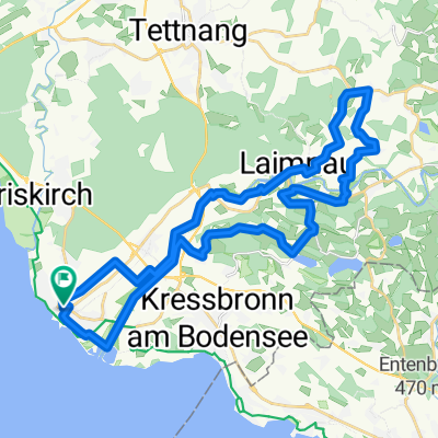
B-See Langenargen - Lindau
A cycling route starting in Langenargen, Baden-Wurttemberg, Germany.
Overview
About this route
- -:--
- Duration
- 14.8 km
- Distance
- 34 m
- Ascent
- 33 m
- Descent
- ---
- Avg. speed
- ---
- Max. altitude
Route quality
Waytypes & surfaces along the route
Waytypes
Quiet road
9.1 km
(61 %)
Road
1.9 km
(13 %)
Surfaces
Paved
14.1 km
(95 %)
Unpaved
0.5 km
(4 %)
Asphalt
13.9 km
(94 %)
Loose gravel
0.5 km
(4 %)
Continue with Bikemap
Use, edit, or download this cycling route
You would like to ride B-See Langenargen - Lindau or customize it for your own trip? Here is what you can do with this Bikemap route:
Free features
- Save this route as favorite or in collections
- Copy & plan your own version of this route
- Sync your route with Garmin or Wahoo
Premium features
Free trial for 3 days, or one-time payment. More about Bikemap Premium.
- Navigate this route on iOS & Android
- Export a GPX / KML file of this route
- Create your custom printout (try it for free)
- Download this route for offline navigation
Discover more Premium features.
Get Bikemap PremiumFrom our community
Other popular routes starting in Langenargen
 Tour 2 Lindau
- Distance
- 44.1 km
- Ascent
- 228 m
- Descent
- 225 m
- Location
- Langenargen, Baden-Wurttemberg, Germany
 Langenargen-Schleinsee-Badhütten-Schöre-Laimnau-Gießenbrücke-Langenargen
- Distance
- 33.9 km
- Ascent
- 399 m
- Descent
- 378 m
- Location
- Langenargen, Baden-Wurttemberg, Germany
 Langenargen Wangen Lindau Langenargen
- Distance
- 73.7 km
- Ascent
- 601 m
- Descent
- 601 m
- Location
- Langenargen, Baden-Wurttemberg, Germany
 Rennrad Trainingsrunde von Thomas Bischof
- Distance
- 65.2 km
- Ascent
- 887 m
- Descent
- 870 m
- Location
- Langenargen, Baden-Wurttemberg, Germany
 BW-10 Etappe 10 - Langenargen - Wangen im Allgäu
- Distance
- 37.1 km
- Ascent
- 489 m
- Descent
- 321 m
- Location
- Langenargen, Baden-Wurttemberg, Germany
 Langenargen Schleinseee Wasserburg
- Distance
- 17.6 km
- Ascent
- 187 m
- Descent
- 183 m
- Location
- Langenargen, Baden-Wurttemberg, Germany
 Camp Gohren - Camp Rohrspitz Salzmann
- Distance
- 33.4 km
- Ascent
- 0 m
- Descent
- 0 m
- Location
- Langenargen, Baden-Wurttemberg, Germany
 Bodensee Hinterland
- Distance
- 33.8 km
- Ascent
- 453 m
- Descent
- 451 m
- Location
- Langenargen, Baden-Wurttemberg, Germany
Open it in the app