

92 kn Challenge
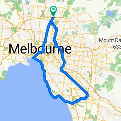
A cycling route starting in Thomastown, Victoria, Australia.
Overview
About this route
M80 - Eastlink - Scoresby - Clifton Hill - M80
- -:--
- Duration
- 92.3 km
- Distance
- 330 m
- Ascent
- 330 m
- Descent
- ---
- Avg. speed
- ---
- Max. altitude

Route quality
Waytypes & surfaces along the route
Waytypes
Cycleway
73.5 km
(80 %)
Quiet road
11.4 km
(12 %)
Surfaces
Paved
81.2 km
(88 %)
Unpaved
5.2 km
(6 %)
Concrete
36.2 km
(39 %)
Asphalt
32.9 km
(36 %)
Continue with Bikemap
Use, edit, or download this cycling route
You would like to ride 92 kn Challenge or customize it for your own trip? Here is what you can do with this Bikemap route:
Free features
- Save this route as favorite or in collections
- Copy & plan your own version of this route
- Split it into stages to create a multi-day tour
- Sync your route with Garmin or Wahoo
Premium features
Free trial for 3 days, or one-time payment. More about Bikemap Premium.
- Navigate this route on iOS & Android
- Export a GPX / KML file of this route
- Create your custom printout (try it for free)
- Download this route for offline navigation
Discover more Premium features.
Get Bikemap PremiumFrom our community
Other popular routes starting in Thomastown
 Settlement Rd, Thomastown to 1020B Lygon St, Carlton North
- Distance
- 15 km
- Ascent
- 122 m
- Descent
- 192 m
- Location
- Thomastown, Victoria, Australia
 Keon Park to Federation Square
- Distance
- 31.6 km
- Ascent
- 111 m
- Descent
- 200 m
- Location
- Thomastown, Victoria, Australia
 Dalton Road 69B, Thomastown to Dalton Road 40A, Thomastown
- Distance
- 110.4 km
- Ascent
- 479 m
- Descent
- 479 m
- Location
- Thomastown, Victoria, Australia
 Metropolitan Ring Road Path, Thomastown to Citylink Tollway, North Melbourne
- Distance
- 17.8 km
- Ascent
- 41 m
- Descent
- 142 m
- Location
- Thomastown, Victoria, Australia
 92 kn Challenge
- Distance
- 92.3 km
- Ascent
- 330 m
- Descent
- 330 m
- Location
- Thomastown, Victoria, Australia
 6A Tuscan Ct, Thomastown to 27 Binnak Dr, Watsonia North
- Distance
- 9.8 km
- Ascent
- 124 m
- Descent
- 136 m
- Location
- Thomastown, Victoria, Australia
 4 Waratah Street, Thomastown to 21 Plane Street, Thomastown
- Distance
- 0.6 km
- Ascent
- 0 m
- Descent
- 0 m
- Location
- Thomastown, Victoria, Australia
 longer one
- Distance
- 37.2 km
- Ascent
- 198 m
- Descent
- 197 m
- Location
- Thomastown, Victoria, Australia
Open it in the app