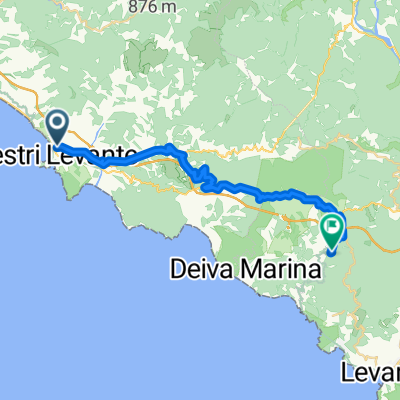
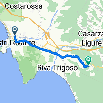
- 80 km
- 1,867 m
- 1,867 m
- Sestri Levante, Liguria, Italy
Sestri Levante-Rocche S.Anna-Santa Giulia-Lavagna
A cycling route starting in Sestri Levante, Liguria, Italy.
Overview
About this route
This route includes a final variant to reach Cavi di Lavagna, where we will be staying.
The original route goes through Costarossa, San Bernardo, and arrives at Sestri Levante station.
- -:--
- Duration
- 20.5 km
- Distance
- 543 m
- Ascent
- 545 m
- Descent
- ---
- Avg. speed
- ---
- Max. altitude
Mauro Martelli
created this 4 years ago
Route quality
Waytypes & surfaces along the route
Waytypes
Road
7.4 km
(36 %)
Quiet road
5.9 km
(29 %)
Surfaces
Paved
4.5 km
(22 %)
Unpaved
3.7 km
(18 %)
Asphalt
4.3 km
(21 %)
Ground
3.5 km
(17 %)
Continue with Bikemap
Use, edit, or download this cycling route
You would like to ride Sestri Levante-Rocche S.Anna-Santa Giulia-Lavagna or customize it for your own trip? Here is what you can do with this Bikemap route:
Free features
- Save this route as favorite or in collections
- Copy & plan your own version of this route
- Sync your route with Garmin or Wahoo
Premium features
Free trial for 3 days, or one-time payment. More about Bikemap Premium.
- Navigate this route on iOS & Android
- Export a GPX / KML file of this route
- Create your custom printout (try it for free)
- Download this route for offline navigation
Discover more Premium features.
Get Bikemap PremiumFrom our community
Other popular routes starting in Sestri Levante
- Sestri Levante
- VARIANTE - "MIMOSE"
- 2.5 km
- 36 m
- 329 m
- Sestri Levante, Liguria, Italy
- Sestri-Bracco-Borghetto-Termine-Levanto-Guaitarola-Sestri
- 98.4 km
- 1,807 m
- 1,807 m
- Sestri Levante, Liguria, Italy
- Da Via Fascie bivio S. Bartolomeo a Via dei Carpentieri
- 87.4 km
- 1,657 m
- 1,677 m
- Sestri Levante, Liguria, Italy
- Piazzale della Stazione 4, Sestri Levante nach Località Prae 1, Framura
- 27.4 km
- 0 m
- 3 m
- Sestri Levante, Liguria, Italy
- Sestri-pisa
- 125.9 km
- 756 m
- 762 m
- Sestri Levante, Liguria, Italy
- Piazzale della Stazione, Sestri Levante - Sestri Levante
- 5.8 km
- 160 m
- 6 m
- Sestri Levante, Liguria, Italy
- Sestri Levante-Cà Marcantonio-Passo Bocco di Bargone-Sestri L.
- 60.7 km
- 1,335 m
- 1,331 m
- Sestri Levante, Liguria, Italy
Open it in the app


