

NR330: Niederrheintour zum Ooij-Polder und durch die Düffel
A cycling route starting in Kranenburg, North Rhine-Westphalia, Germany.
Overview
About this route
We start at the train station of the borderland draisine in Kranenburg and initially head north into the Düffel, part of the nature reserve "Düffel - Kellener Altrhein and river marshes".
The Düffel is located in the Rhine marshes and was regularly flooded by the Rhine in ancient times. The Rhine's floods constantly enriched the once barren sandy soil with the river’s sediments. To utilize the fertile soil of the Düffel, the area was diked and drained (polder). To protect the valuable soil from wind erosion, farmers planted hawthorn hedges, which are still often found today and provide an important refuge for various songbird species. Here and in the various wetlands, many now rare bird species can be spotted. During the winter months, northern wild geese use the Düffel as a resting and wintering area.
Just before the German-Dutch border, we reach Zyfflich, located on a long ridge of glacial sand. The Düffel was home to a strong population of white storks until the beginning of the 19th century. Extensive agriculture and soil drainage drove the storks away from the Düffel. Only 50 years later did they return, after some nesting boxes were built in Zyfflich. Today, the storks feel so comfortable in Zyfflich that some of them no longer undertake the migratory journey to southern Europe and North Africa in winter but simply stay here. This earned Zyfflich the nickname "stork village". Notable here, alongside the various stork nests, is the former collegiate church of St. Martin from the 11th century.
We leave the stork village and continue towards the Rhine. Shortly after, we cross the border and reach the "Thorn Mill" in the Ooij polder. The 500-year-old kokermill was completely destroyed at the end of World War II and only rebuilt in 2015. In the earthen rampart of the mill, there is a modern restaurant with a view of the Düffel.
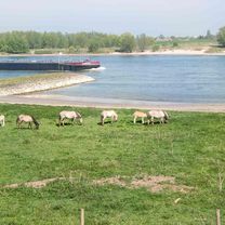
On the dike we bypass the village of Ooij and reach the Waal, one of the estuarine arms of the Rhine (Dutch: Rijn). From the dike, there are repeated marvelous views of the river and the river marshes with countless water birds, storks, and a herd of Konik horses.
In Kekerdom, we encounter the Millingerwaard inside a bend of the Waal. The old summer dike was removed, allowing this area to be flooded during every high-water event, thereby relieving the river. Formerly agricultural lands have been renaturalized. Thus, the Waard regained its old appearance and function with its river dunes and old arms. Grazing animals such as Galloway cattle and Konik horses ensure a balanced flora. At the same time, beavers have been introduced, and gradually other animal and plant species have returned. There is hope that rare sea eagles will also show up here soon. A number of cycling and walking paths cross the Waard, and a cozy tea garden invites you to linger. Therefore, a detour into this impressive nature reserve is certainly recommended.
Shortly after Millinger Waard, we recognize the diverging Nederrijn on the other side of the river, marking the beginning of the river delta. Upstream from here, the Rhine (Dutch: Rijn) is mentioned again. We are now in Millingen aan de Rijn, a small Dutch municipality in the Dutch-German border region. At the exit of Millingen, we cross the border and are again in Germany. Through Keeken, we arrive at Düffelward. If you use the path on the dike instead of the bike path along the road, you will have a beautiful view of Düffelward on the other side of the Rhine with the Salmorth peninsula and the small village of Schenkenschanz.
Here in Düffelward, we leave the Rhine and cross the Düffel again heading south. Behind Mehr, we encounter the Kranenburger Bruch, one of the last larger low moors in the lower Rhine region. Due to long-term agricultural use, a variety of habitats have developed, benefiting many species of insects, amphibians, birds, and plants today. The diverse marsh landscape extends all the way to the edge of Kranenburg, the starting point for this bike tour.
Before we head back home, we should definitely take a short walk through the historic town center with the Katharinenhof Museum, the town barn, and the windmill tower, the landmark of Kranenburg.
- -:--
- Duration
- 42.1 km
- Distance
- 21 m
- Ascent
- 20 m
- Descent
- ---
- Avg. speed
- 18 m
- Max. altitude

Route photos


Route quality
Waytypes & surfaces along the route
Waytypes
Quiet road
24.4 km
(58 %)
Road
7.2 km
(17 %)
Surfaces
Paved
26.9 km
(64 %)
Asphalt
16.8 km
(40 %)
Paved (undefined)
10.1 km
(24 %)
Undefined
15.2 km
(36 %)
Continue with Bikemap
Use, edit, or download this cycling route
You would like to ride NR330: Niederrheintour zum Ooij-Polder und durch die Düffel or customize it for your own trip? Here is what you can do with this Bikemap route:
Free features
- Save this route as favorite or in collections
- Copy & plan your own version of this route
- Sync your route with Garmin or Wahoo
Premium features
Free trial for 3 days, or one-time payment. More about Bikemap Premium.
- Navigate this route on iOS & Android
- Export a GPX / KML file of this route
- Create your custom printout (try it for free)
- Download this route for offline navigation
Discover more Premium features.
Get Bikemap PremiumFrom our community
Other popular routes starting in Kranenburg
 Groesbeek
- Distance
- 31.2 km
- Ascent
- 265 m
- Descent
- 265 m
- Location
- Kranenburg, North Rhine-Westphalia, Germany
 Rondje Reichswald
- Distance
- 46.4 km
- Ascent
- 401 m
- Descent
- 401 m
- Location
- Kranenburg, North Rhine-Westphalia, Germany
 Maasroute
- Distance
- 70.4 km
- Ascent
- 81 m
- Descent
- 82 m
- Location
- Kranenburg, North Rhine-Westphalia, Germany
 DD 9.
DD 9.- Distance
- 53.5 km
- Ascent
- 111 m
- Descent
- 107 m
- Location
- Kranenburg, North Rhine-Westphalia, Germany
 Trailrondje Reichswald
- Distance
- 16.4 km
- Ascent
- 146 m
- Descent
- 149 m
- Location
- Kranenburg, North Rhine-Westphalia, Germany
 Berg & DalTour90Km
- Distance
- 90.1 km
- Ascent
- 271 m
- Descent
- 267 m
- Location
- Kranenburg, North Rhine-Westphalia, Germany
 Groesbeek NK Marathon 2010
- Distance
- 85.1 km
- Ascent
- 369 m
- Descent
- 369 m
- Location
- Kranenburg, North Rhine-Westphalia, Germany
 NR867c: Nijmegen, Rheinmarschen und eine einsame Burg
- Distance
- 51.2 km
- Ascent
- 139 m
- Descent
- 138 m
- Location
- Kranenburg, North Rhine-Westphalia, Germany
Open it in the app