

Recovered Route
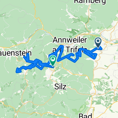
A cycling route starting in Ranschbach, Rhineland-Palatinate, Germany.
Overview
About this route
- 2 h 8 min
- Duration
- 3.1 km
- Distance
- 308 m
- Ascent
- 88 m
- Descent
- 1.4 km/h
- Avg. speed
- ---
- Max. altitude
Route photos


Continue with Bikemap
Use, edit, or download this cycling route
You would like to ride Recovered Route or customize it for your own trip? Here is what you can do with this Bikemap route:
Free features
- Save this route as favorite or in collections
- Copy & plan your own version of this route
- Sync your route with Garmin or Wahoo
Premium features
Free trial for 3 days, or one-time payment. More about Bikemap Premium.
- Navigate this route on iOS & Android
- Export a GPX / KML file of this route
- Create your custom printout (try it for free)
- Download this route for offline navigation
Discover more Premium features.
Get Bikemap PremiumFrom our community
Other popular routes starting in Ranschbach
 Ransbach-Gleiszellen
- Distance
- 32.3 km
- Ascent
- 442 m
- Descent
- 432 m
- Location
- Ranschbach, Rhineland-Palatinate, Germany
 Weinfeld Dorfertour von Ranschbach
- Distance
- 44.8 km
- Ascent
- 281 m
- Descent
- 348 m
- Location
- Ranschbach, Rhineland-Palatinate, Germany
 Durch den Wein zur Burg Trifels
- Distance
- 16.7 km
- Ascent
- 984 m
- Descent
- 699 m
- Location
- Ranschbach, Rhineland-Palatinate, Germany
 Weinstraße 35, Ranschbach nach Am Hasensprung 2, Leinsweiler
- Distance
- 3.2 km
- Ascent
- 57 m
- Descent
- 39 m
- Location
- Ranschbach, Rhineland-Palatinate, Germany
 От Ranschbach до Josefshof
- Distance
- 75.7 km
- Ascent
- 3,270 m
- Descent
- 3,246 m
- Location
- Ranschbach, Rhineland-Palatinate, Germany
 Am Schwellbau, Ranschbach nach Landkommissärstraße 1, Landau in der Pfalz
- Distance
- 11.4 km
- Ascent
- 51 m
- Descent
- 144 m
- Location
- Ranschbach, Rhineland-Palatinate, Germany
 Recovered Route
- Distance
- 3.1 km
- Ascent
- 308 m
- Descent
- 88 m
- Location
- Ranschbach, Rhineland-Palatinate, Germany
 0122a Ranschbach Hauenstein Rundtour
- Distance
- 48 km
- Ascent
- 324 m
- Descent
- 310 m
- Location
- Ranschbach, Rhineland-Palatinate, Germany
Open it in the app