

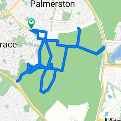
Gungaderra Grasslands - routes on signboard
A cycling route starting in Kaleen, Australian Capital Territory, Australia.
Overview
About this route
- -:--
- Duration
- 12.1 km
- Distance
- 147 m
- Ascent
- 147 m
- Descent
- ---
- Avg. speed
- ---
- Max. altitude

Route highlights
Points of interest along the route
Point of interest after 0.3 km
Car park
Point of interest after 1.9 km
Fence crossing
Point of interest after 3.4 km
Possible entry here
Point of interest after 4.3 km
Drooka Crescent entry (3 entries along this street)
Point of interest after 4.6 km
Cocoparra Crescent entry
Point of interest after 4.8 km
Barton Highway entry
Point of interest after 5.2 km
Gunghalin Hill
Point of interest after 6.7 km
Creek crossing possible here
Point of interest after 6.7 km
Gungahlin Homestead
Point of interest after 6.7 km
Australian National Wildlife Collection
Point of interest after 6.9 km
Spiders Hill
Point of interest after 7.5 km
Gungaderra Grassland
Point of interest after 7.5 km
Creek crossing possible here
Point of interest after 7.9 km
Hill (small)
Point of interest after 10.2 km
Bollard Street entry
Point of interest after 10.9 km
Hill (small)
Continue with Bikemap
Use, edit, or download this cycling route
You would like to ride Gungaderra Grasslands - routes on signboard or customize it for your own trip? Here is what you can do with this Bikemap route:
Free features
- Save this route as favorite or in collections
- Copy & plan your own version of this route
- Sync your route with Garmin or Wahoo
Premium features
Free trial for 3 days, or one-time payment. More about Bikemap Premium.
- Navigate this route on iOS & Android
- Export a GPX / KML file of this route
- Create your custom printout (try it for free)
- Download this route for offline navigation
Discover more Premium features.
Get Bikemap PremiumFrom our community
Other popular routes starting in Kaleen
 Gungaderra Grasslands - routes on signboard
- Distance
- 12.1 km
- Ascent
- 147 m
- Descent
- 147 m
- Location
- Kaleen, Australian Capital Territory, Australia
 Stromlo
- Distance
- 51.6 km
- Ascent
- 499 m
- Descent
- 499 m
- Location
- Kaleen, Australian Capital Territory, Australia
 ride from Watson to Gungahlin
- Distance
- 17.6 km
- Ascent
- 115 m
- Descent
- 84 m
- Location
- Kaleen, Australian Capital Territory, Australia
 6r Centenary Trail - Northern Border Campsite to Watson
- Distance
- 16.2 km
- Ascent
- 156 m
- Descent
- 232 m
- Location
- Kaleen, Australian Capital Territory, Australia
 Mulligans Flat Circuit
- Distance
- 48 km
- Ascent
- 493 m
- Descent
- 492 m
- Location
- Kaleen, Australian Capital Territory, Australia
 Gungaderra Grasslands walk through boggy creek
- Distance
- 10.1 km
- Ascent
- 139 m
- Descent
- 140 m
- Location
- Kaleen, Australian Capital Territory, Australia
 45 Norman Fisher cct to LInnaeus way ANU
- Distance
- 6.3 km
- Ascent
- 45 m
- Descent
- 83 m
- Location
- Kaleen, Australian Capital Territory, Australia
 bedulluck sutton loop
- Distance
- 81.7 km
- Ascent
- 377 m
- Descent
- 374 m
- Location
- Kaleen, Australian Capital Territory, Australia
Open it in the app