

Mulanggari Grasslands
A cycling route starting in Kaleen, Australian Capital Territory, Australia.
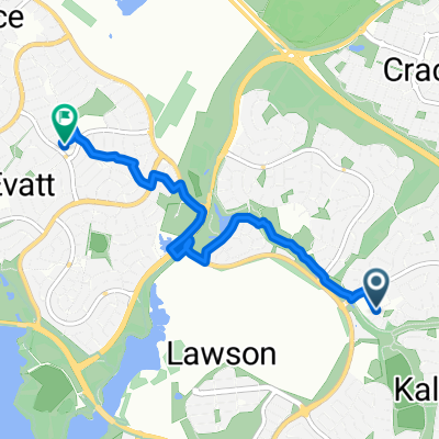
Overview
About this route
- -:--
- Duration
- 11.1 km
- Distance
- 76 m
- Ascent
- 79 m
- Descent
- ---
- Avg. speed
- 632 m
- Max. altitude

Route highlights
Points of interest along the route
Point of interest after 2.2 km
Gungahlin Drive entry
Point of interest after 3.4 km
Crace Grassland
Point of interest after 3.4 km
Norwood Park Crematorium
Point of interest after 3.4 km
Gungahlin Cemetery
Point of interest after 3.5 km
Crace Hill
Point of interest after 4 km
Patrick White Pond
Point of interest after 4.4 km
Oodegeroo Street entry
Point of interest after 8.1 km
Mulanggari Grasslands
Continue with Bikemap
Use, edit, or download this cycling route
You would like to ride Mulanggari Grasslands or customize it for your own trip? Here is what you can do with this Bikemap route:
Free features
- Save this route as favorite or in collections
- Copy & plan your own version of this route
- Sync your route with Garmin or Wahoo
Premium features
Free trial for 3 days, or one-time payment. More about Bikemap Premium.
- Navigate this route on iOS & Android
- Export a GPX / KML file of this route
- Create your custom printout (try it for free)
- Download this route for offline navigation
Discover more Premium features.
Get Bikemap PremiumFrom our community
Other popular routes starting in Kaleen
 Gungaderra Grasslands walk including shallow creek
- Distance
- 11.4 km
- Ascent
- 136 m
- Descent
- 134 m
- Location
- Kaleen, Australian Capital Territory, Australia
 Crace to taylor loop
- Distance
- 17.4 km
- Ascent
- 411 m
- Descent
- 408 m
- Location
- Kaleen, Australian Capital Territory, Australia
 Mulanggari and Crace Grasslands
- Distance
- 17.9 km
- Ascent
- 106 m
- Descent
- 108 m
- Location
- Kaleen, Australian Capital Territory, Australia
 From Kaleen to Evatt
- Distance
- 5.4 km
- Ascent
- 35 m
- Descent
- 14 m
- Location
- Kaleen, Australian Capital Territory, Australia
 3 Centenary Trail - Northern Border Campsite to Hall
- Distance
- 13.1 km
- Ascent
- 208 m
- Descent
- 280 m
- Location
- Kaleen, Australian Capital Territory, Australia
 10-16-2 National Trail Mulligan's Flat to Harcourt Hill
- Distance
- 15.6 km
- Ascent
- 189 m
- Descent
- 230 m
- Location
- Kaleen, Australian Capital Territory, Australia
 Sutton Loop
- Distance
- 46.7 km
- Ascent
- 350 m
- Descent
- 350 m
- Location
- Kaleen, Australian Capital Territory, Australia
 ride from Watson to Gungahlin
- Distance
- 17.6 km
- Ascent
- 115 m
- Descent
- 84 m
- Location
- Kaleen, Australian Capital Territory, Australia
Open it in the app