

Ciley Hill RD
A cycling route starting in Jericho, Vermont, United States.
Overview
About this route
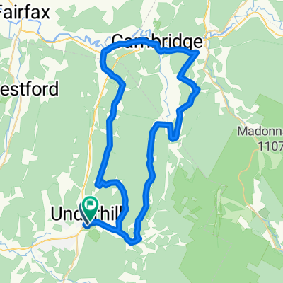
As you start out on the first 1mile on orr rd you will experience a slight incline. you go down the decline about 200feet switching to packard rd. You then go along the flat part of route 15 for about 1/4 mile you will turn right on to ciley hill rd. In the 5 miles you are on this rd you will experience an 800 foot climb and then you will rapidly drop 400feet before looping back to orr rd. This route is not advised for the novice biker.
- -:--
- Duration
- 16.6 km
- Distance
- 237 m
- Ascent
- 238 m
- Descent
- ---
- Avg. speed
- ---
- Max. altitude
Route quality
Waytypes & surfaces along the route
Waytypes
Quiet road
11.6 km
(70 %)
Access road
0.3 km
(2 %)
Undefined
4.6 km
(28 %)
Surfaces
Paved
5.3 km
(32 %)
Unpaved
10.6 km
(64 %)
Gravel
10.6 km
(64 %)
Asphalt
4.6 km
(28 %)
Continue with Bikemap
Use, edit, or download this cycling route
You would like to ride Ciley Hill RD or customize it for your own trip? Here is what you can do with this Bikemap route:
Free features
- Save this route as favorite or in collections
- Copy & plan your own version of this route
- Sync your route with Garmin or Wahoo
Premium features
Free trial for 3 days, or one-time payment. More about Bikemap Premium.
- Navigate this route on iOS & Android
- Export a GPX / KML file of this route
- Create your custom printout (try it for free)
- Download this route for offline navigation
Discover more Premium features.
Get Bikemap PremiumFrom our community
Other popular routes starting in Jericho
 Sand Hill Road 128, Essex to Lyon Lane 8, Essex
- Distance
- 3.2 km
- Ascent
- 9 m
- Descent
- 18 m
- Location
- Jericho, Vermont, United States
 English to Irish Settlement
- Distance
- 53.5 km
- Ascent
- 1,020 m
- Descent
- 1,015 m
- Location
- Jericho, Vermont, United States
 Matt north
- Distance
- 85.6 km
- Ascent
- 1,655 m
- Descent
- 1,655 m
- Location
- Jericho, Vermont, United States
 235–255 W Sleepy Hollow Rd, Essex Junction to 1 S Prospect St, Burlington
- Distance
- 18.4 km
- Ascent
- 116 m
- Descent
- 221 m
- Location
- Jericho, Vermont, United States
 Cyclo-camping Pion-L-Giguère 06-2010 Jour7v2
- Distance
- 69.3 km
- Ascent
- 682 m
- Descent
- 779 m
- Location
- Jericho, Vermont, United States
 NE of Fairfax Loop
- Distance
- 69 km
- Ascent
- 577 m
- Descent
- 576 m
- Location
- Jericho, Vermont, United States
 Jericho to Barre
- Distance
- 69.1 km
- Ascent
- 393 m
- Descent
- 414 m
- Location
- Jericho, Vermont, United States
 Sand Hill Road 156, Essex to Lyon Lane 2, Essex
- Distance
- 3.1 km
- Ascent
- 8 m
- Descent
- 8 m
- Location
- Jericho, Vermont, United States
Open it in the app