


*AMTB Czupel-Magurka Wil. 09.04.2011
- 20 km
- 689 m
- 690 m
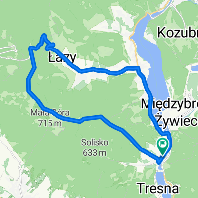
- Czernichów, Silesian Voivodeship, Poland
A cycling route starting in Czernichów, Silesian Voivodeship, Poland.
Overview
Start: Czernichów
niebieskim na Suchy Wierch, Rogacz.
Czupel, po drodze piękne widoczki na lewo i prawo.
kontynuujemy niebieskim na Magurkę Wilkowicką
PTTK MAgura Wilkowicka.
zjazd niebieskim na przeł. przegibek [Straconka]
zjazd niestety asfaltem do czernichowa, (awaria buta)
Meta: Czernichów.
created this 14 years ago
Route quality
Road
5.8 km
(29 %)
Track
5 km
(25 %)
Paved
10 km
(50 %)
Unpaved
7.2 km
(36 %)
Asphalt
10 km
(50 %)
Ground
7.2 km
(36 %)
Undefined
2.8 km
(14 %)
Continue with Bikemap
You would like to ride *AMTB Czupel-Magurka Wil. 09.04.2011 or customize it for your own trip? Here is what you can do with this Bikemap route:
Free trial for 3 days, or one-time payment. More about Bikemap Premium.
Discover more Premium features.
Get Bikemap PremiumFrom our community
Open it in the app


