
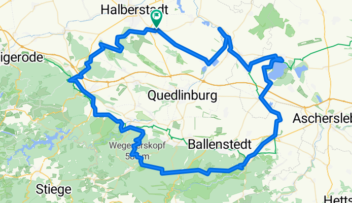
Harsleben Concordia-See undUnterharz
A cycling route starting in Harsleben, Saxony-Anhalt, Germany.
Overview
About this route
Anfangs gemütliche Tour, die mit der Fahrt in den Unterharz eine gewisse Würze bekommt.
Von Harsleben geht es bis zur Mündung der Selke in die Bode und weiter den Selke-Radweg mit Abstecher zum Concordia-See bis nach Meisdorf. Weiter die Meisdorfer Trifft hinauf über Hohe Warte, Bremer Teich Richtung Wurmbachtal ( unterhalb Viktorshöhe ). Bergab führt die Tour nach Neinstedt/Thale und den R1-Radweg bis zum Mönchmühlen-Teich. Nach einem "Weizenbier" geht die Fahrt entlang des Goldbachs über Langenstein und die Klusberge ans Ziel.
- -:--
- Duration
- 118.9 km
- Distance
- 554 m
- Ascent
- 553 m
- Descent
- ---
- Avg. speed
- ---
- Avg. speed

Route quality
Waytypes & surfaces along the route
Waytypes
Track
52.2 km
(44 %)
Quiet road
27.2 km
(23 %)
Surfaces
Paved
46.7 km
(39 %)
Unpaved
51.7 km
(43 %)
Asphalt
35.7 km
(30 %)
Gravel
32.8 km
(28 %)
Route highlights
Points of interest along the route
Point of interest after 15.8 km
Selke-Mündung in die Bode
Point of interest after 69.2 km
Abzweig ins Hagental nach Gernrode
Point of interest after 75.4 km
Abzweig ins Wurmbachtal
Continue with Bikemap
Use, edit, or download this cycling route
You would like to ride Harsleben Concordia-See undUnterharz or customize it for your own trip? Here is what you can do with this Bikemap route:
Free features
- Save this route as favorite or in collections
- Copy & plan your own version of this route
- Split it into stages to create a multi-day tour
- Sync your route with Garmin or Wahoo
Premium features
Free trial for 3 days, or one-time payment. More about Bikemap Premium.
- Navigate this route on iOS & Android
- Export a GPX / KML file of this route
- Create your custom printout (try it for free)
- Download this route for offline navigation
Discover more Premium features.
Get Bikemap PremiumFrom our community
Other popular routes starting in Harsleben
 Ostharz von Selke bis Bode
- Distance
- 116.6 km
- Ascent
- 913 m
- Descent
- 911 m
- Location
- Harsleben, Saxony-Anhalt, Germany
 Hochwasser-Tour 27.7.17
- Distance
- 47 km
- Ascent
- 102 m
- Descent
- 102 m
- Location
- Harsleben, Saxony-Anhalt, Germany
 Brocken und Huy
- Distance
- 150.7 km
- Ascent
- 1,103 m
- Descent
- 1,100 m
- Location
- Harsleben, Saxony-Anhalt, Germany
 Kaffeefahrt zur Roten Mühle
- Distance
- 64.9 km
- Ascent
- 493 m
- Descent
- 497 m
- Location
- Harsleben, Saxony-Anhalt, Germany
 Harsleben Ditfurt Quedlinburg Langenstein
- Distance
- 42.8 km
- Ascent
- 129 m
- Descent
- 87 m
- Location
- Harsleben, Saxony-Anhalt, Germany
 Unterharz - Tour
- Distance
- 102.5 km
- Ascent
- 651 m
- Descent
- 650 m
- Location
- Harsleben, Saxony-Anhalt, Germany
 Oberharz-Tour
- Distance
- 183.7 km
- Ascent
- 990 m
- Descent
- 990 m
- Location
- Harsleben, Saxony-Anhalt, Germany
 Brocken bis Selketal
- Distance
- 167.4 km
- Ascent
- 1,269 m
- Descent
- 1,269 m
- Location
- Harsleben, Saxony-Anhalt, Germany
Open it in the app