

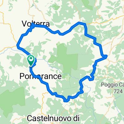
San Dalmazio.Mazzolla-Masso Fanciulle-Rocca Sillana-San Dalmazio
A cycling route starting in Pomarance, Tuscany, Italy.
Overview
About this route
MTB route in an anticlockwise direction
San Dalmazio, Monteguidi (km 19.3 elevation 510), Dispensa di Tatti (km 30.4 elevation 820), Luppiano Castle (km 33.9 elevation 850), diversion to Mazzolla (km 40.5 elevation 1050), Santa Dionisia (km 50.6 elevation 1100), Masso delle Fanciulle (km 54.5 elevation 1110), Rocca Sillana (km 62.1 elevation 1500), San Dalmazio (km 64 elevation 1500)
- -:--
- Duration
- 64 km
- Distance
- 1,376 m
- Ascent
- 1,358 m
- Descent
- ---
- Avg. speed
- 510 m
- Max. altitude
Route quality
Waytypes & surfaces along the route
Waytypes
Track
42.9 km
(67 %)
Quiet road
16 km
(25 %)
Surfaces
Paved
14.1 km
(22 %)
Unpaved
42.9 km
(67 %)
Gravel
19.2 km
(30 %)
Asphalt
14.1 km
(22 %)
Continue with Bikemap
Use, edit, or download this cycling route
You would like to ride San Dalmazio.Mazzolla-Masso Fanciulle-Rocca Sillana-San Dalmazio or customize it for your own trip? Here is what you can do with this Bikemap route:
Free features
- Save this route as favorite or in collections
- Copy & plan your own version of this route
- Sync your route with Garmin or Wahoo
Premium features
Free trial for 3 days, or one-time payment. More about Bikemap Premium.
- Navigate this route on iOS & Android
- Export a GPX / KML file of this route
- Create your custom printout (try it for free)
- Download this route for offline navigation
Discover more Premium features.
Get Bikemap PremiumFrom our community
Other popular routes starting in Pomarance
 GB. GF Paolo Bettini Medio 2012
- Distance
- 99.8 km
- Ascent
- 902 m
- Descent
- 902 m
- Location
- Pomarance, Tuscany, Italy
 Terre di Pisa Bike Tour
- Distance
- 45.2 km
- Ascent
- 372 m
- Descent
- 746 m
- Location
- Pomarance, Tuscany, Italy
 San Dalmazio.Mazzolla-Masso Fanciulle-Rocca Sillana-San Dalmazio
- Distance
- 64 km
- Ascent
- 1,376 m
- Descent
- 1,358 m
- Location
- Pomarance, Tuscany, Italy
 Volterra_Pomarance_Castelnuovo_II.part
- Distance
- 37.2 km
- Ascent
- 1,155 m
- Descent
- 882 m
- Location
- Pomarance, Tuscany, Italy
 Pomarance-Casole-Volterra
- Distance
- 75.2 km
- Ascent
- 1,608 m
- Descent
- 1,735 m
- Location
- Pomarance, Tuscany, Italy
 Pomarance-Micciano-Montecatini-Pomarance
- Distance
- 52.7 km
- Ascent
- 1,128 m
- Descent
- 1,245 m
- Location
- Pomarance, Tuscany, Italy
 Trip from Montegemoli Bivio
- Distance
- 16.7 km
- Ascent
- 375 m
- Descent
- 376 m
- Location
- Pomarance, Tuscany, Italy
 Pomarance-Marina di Bibbona
- Distance
- 42.2 km
- Ascent
- 300 m
- Descent
- 541 m
- Location
- Pomarance, Tuscany, Italy
Open it in the app