

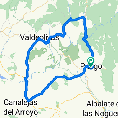
Overview
About this route
- -:--
- Duration
- 156.4 km
- Distance
- 1,920 m
- Ascent
- 1,687 m
- Descent
- ---
- Avg. speed
- 1,610 m
- Max. altitude

Part of
Montañas vacias
5 stages
Route quality
Waytypes & surfaces along the route
Waytypes
Road
46.9 km
(30 %)
Quiet road
37.5 km
(24 %)
Surfaces
Paved
23.5 km
(15 %)
Asphalt
17.2 km
(11 %)
Paved (undefined)
6.3 km
(4 %)
Undefined
133 km
(85 %)
Route highlights
Points of interest along the route
Point of interest after 10.3 km
Playa cañamanes
Point of interest after 65.5 km
cascada rio cuerbo
Continue with Bikemap
Use, edit, or download this cycling route
You would like to ride MV5.1-jhl or customize it for your own trip? Here is what you can do with this Bikemap route:
Free features
- Save this route as favorite or in collections
- Copy & plan your own version of this route
- Split it into stages to create a multi-day tour
- Sync your route with Garmin or Wahoo
Premium features
Free trial for 3 days, or one-time payment. More about Bikemap Premium.
- Navigate this route on iOS & Android
- Export a GPX / KML file of this route
- Create your custom printout (try it for free)
- Download this route for offline navigation
Discover more Premium features.
Get Bikemap PremiumFrom our community
Other popular routes starting in Priego
 Priego - Poyatos - Beteta - Priego
- Distance
- 96.9 km
- Ascent
- 949 m
- Descent
- 964 m
- Location
- Priego, Castille-La Mancha, Spain
 Ruta Priego - Alcantud - El Pozuelo - Peñalén - Beteta - Priego
- Distance
- 97.1 km
- Ascent
- 2,678 m
- Descent
- 2,681 m
- Location
- Priego, Castille-La Mancha, Spain
 Priego-Alcantud-Arandilla-Valdeolivas-Villar del Infantdo-San Pedro-Priego
- Distance
- 63.5 km
- Ascent
- 626 m
- Descent
- 642 m
- Location
- Priego, Castille-La Mancha, Spain
 MV5.1-jhl
- Distance
- 156.4 km
- Ascent
- 1,920 m
- Descent
- 1,687 m
- Location
- Priego, Castille-La Mancha, Spain
 Priego - Vuelta por Trillo
- Distance
- 134.5 km
- Ascent
- 1,215 m
- Descent
- 1,217 m
- Location
- Priego, Castille-La Mancha, Spain
 Priego - El Pozuelo - Villanueva de Alcoron - Peñalen - Beteta - Cañizares - Priego
- Distance
- 110.7 km
- Ascent
- 1,126 m
- Descent
- 1,133 m
- Location
- Priego, Castille-La Mancha, Spain
 La Alcarria.
- Distance
- 121.9 km
- Ascent
- 1,209 m
- Descent
- 1,218 m
- Location
- Priego, Castille-La Mancha, Spain
 Ruta por los puentes de Priego
- Distance
- 98.1 km
- Ascent
- 909 m
- Descent
- 916 m
- Location
- Priego, Castille-La Mancha, Spain
Open it in the app