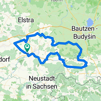
Lausitz und Sächsische Schweiz
A cycling route starting in Frankenthal, Saxony, Germany.
Overview
About this route
Wonderful round tour with very beautiful villages and views. In Ehrenberg, Cunnersdorf and partly also in Stürza miserable asphalt roads. In Ehrenberg with huge holes. Drive carefully! Brilliant view towards Dresden from Lichtenberg on Eichberg! Then definitely try a scoop of ice cream at 'diavolo' in Pulsnitz. You can surely have a good meal in Cunnersdorf at Bockmühle. But be careful, right after there is a short but steep climb. :-)
From Ehrenberg to Wachau I had north-west wind of the worst sort. Well, at least the sun was shining beautifully.
- -:--
- Duration
- 114.4 km
- Distance
- 637 m
- Ascent
- 637 m
- Descent
- ---
- Avg. speed
- ---
- Max. altitude
Route quality
Waytypes & surfaces along the route
Waytypes
- Road - 52.6 km - (46 %) 
- Quiet road - 24 km - (21 %) 
Surfaces
Paved
76.7 km
(67 %)
Unpaved
1.1 km
(1 %)
- Asphalt - 76.7 km - (67 %) 
- Gravel - 1.1 km - (1 %) 
- Undefined - 36.6 km - (32 %) 
Continue with Bikemap
Use, edit, or download this cycling route
You would like to ride Lausitz und Sächsische Schweiz or customize it for your own trip? Here is what you can do with this Bikemap route:
Free features
- Save this route as favorite or in collections
- Copy & plan your own version of this route
- Split it into stages to create a multi-day tour
- Sync your route with Garmin or Wahoo
Premium features
Free trial for 3 days, or one-time payment. More about Bikemap Premium.
- Navigate this route on iOS & Android
- Export a GPX / KML file of this route
- Create your custom printout (try it for free)
- Download this route for offline navigation
Discover more Premium features.
Get Bikemap PremiumFrom our community
Other popular routes starting in Frankenthal
 Goldbach-Luchsenburg-Ohorn-Masenei Goldbach-Luchsenburg-Ohorn-Masenei- Distance
- 34.3 km
- Ascent
- 242 m
- Descent
- 242 m
- Location
- Frankenthal, Saxony, Germany
 
 Bischofswerda - Massenei Rundtour Bischofswerda - Massenei Rundtour- Distance
- 36.5 km
- Ascent
- 269 m
- Descent
- 271 m
- Location
- Frankenthal, Saxony, Germany
 
 Flandern Rundfahrt Flandern Rundfahrt- Distance
- 128.8 km
- Ascent
- 663 m
- Descent
- 664 m
- Location
- Frankenthal, Saxony, Germany
 
 Lausnitzer Heide Lausnitzer Heide- Distance
- 101.9 km
- Ascent
- 446 m
- Descent
- 446 m
- Location
- Frankenthal, Saxony, Germany
 
 UmStolpen60_440 UmStolpen60_440- Distance
- 60 km
- Ascent
- 361 m
- Descent
- 363 m
- Location
- Frankenthal, Saxony, Germany
 
 Goldbach-Rothnaußlitz-Burkau Goldbach-Rothnaußlitz-Burkau- Distance
- 31.7 km
- Ascent
- 280 m
- Descent
- 280 m
- Location
- Frankenthal, Saxony, Germany
 
 LKT-V2 LKT-V2- Distance
- 271.5 km
- Ascent
- 1,635 m
- Descent
- 1,636 m
- Location
- Frankenthal, Saxony, Germany
 
 10-07-13 10-07-13- Distance
- 79.8 km
- Ascent
- 722 m
- Descent
- 722 m
- Location
- Frankenthal, Saxony, Germany
 
Open it in the app

