
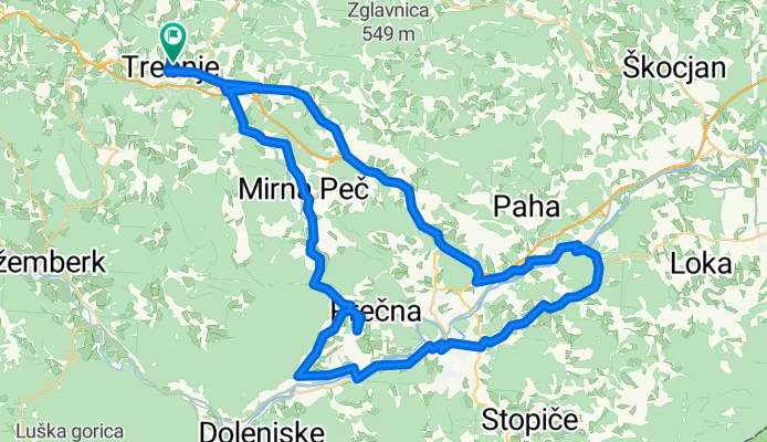
Trebnje - Otočec - Straža - Mirna Peč -Trebnje
A cycling route starting in Trebnje, Trebnje, Slovenia.
Overview
About this route
Trebnje - Otočec - Ratež - Straža, Prečna, Vrhovo, Mirna Peč, Dobrava, Trebnje
Average 21 km/h Average 19°C Time 3:30 10.4.2011 Evgen Tadej
- -:--
- Duration
- 68 km
- Distance
- 557 m
- Ascent
- 557 m
- Descent
- ---
- Avg. speed
- ---
- Max. altitude

Route quality
Waytypes & surfaces along the route
Waytypes
Road
19 km
(28 %)
Quiet road
15.6 km
(23 %)
Surfaces
Paved
44.2 km
(65 %)
Unpaved
1.4 km
(2 %)
Asphalt
44.2 km
(65 %)
Gravel
1.4 km
(2 %)
Undefined
22.4 km
(33 %)
Route highlights
Points of interest along the route
Point of interest after 36.6 km
Pumpa Bar - Radler =)
Point of interest after 48.4 km
Pica =)
Point of interest after 67.5 km
Opara - sladoled =)
Continue with Bikemap
Use, edit, or download this cycling route
You would like to ride Trebnje - Otočec - Straža - Mirna Peč -Trebnje or customize it for your own trip? Here is what you can do with this Bikemap route:
Free features
- Save this route as favorite or in collections
- Copy & plan your own version of this route
- Sync your route with Garmin or Wahoo
Premium features
Free trial for 3 days, or one-time payment. More about Bikemap Premium.
- Navigate this route on iOS & Android
- Export a GPX / KML file of this route
- Create your custom printout (try it for free)
- Download this route for offline navigation
Discover more Premium features.
Get Bikemap PremiumFrom our community
Other popular routes starting in Trebnje
 Obhod dolenjske
- Distance
- 86 km
- Ascent
- 1,743 m
- Descent
- 1,757 m
- Location
- Trebnje, Trebnje, Slovenia
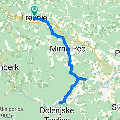
 Trebnje Šmarješke toplice Žužemberk Trebnje
- Distance
- 63.1 km
- Ascent
- 433 m
- Descent
- 433 m
- Location
- Trebnje, Trebnje, Slovenia
 trebnje-trebeljevo-grosuplje-trebnje
- Distance
- 80.8 km
- Ascent
- 808 m
- Descent
- 798 m
- Location
- Trebnje, Trebnje, Slovenia
 Trebnje Dana 20.junij
- Distance
- 63.9 km
- Ascent
- 334 m
- Descent
- 336 m
- Location
- Trebnje, Trebnje, Slovenia
 Trebnje-Šentrupert-Dole pri Litiji-Gabrovka-Čatež-Trebnje
- Distance
- 47 km
- Ascent
- 724 m
- Descent
- 722 m
- Location
- Trebnje, Trebnje, Slovenia
 Trebnje - Letališče Šentvid - Trebnje
- Distance
- 31.8 km
- Ascent
- 385 m
- Descent
- 379 m
- Location
- Trebnje, Trebnje, Slovenia
 PonikveDragatus2021
- Distance
- 59.8 km
- Ascent
- 713 m
- Descent
- 757 m
- Location
- Trebnje, Trebnje, Slovenia
 trebnje, mirna peč, vrhovo, straža, prečna, trebnje
- Distance
- 46.5 km
- Ascent
- 406 m
- Descent
- 406 m
- Location
- Trebnje, Trebnje, Slovenia
Open it in the app