

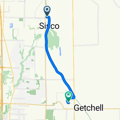
Centennial Trail - Getchel to Snohomish
A cycling route starting in Sisco Heights, Washington, United States.
Overview
About this route
Pretty stop at Lake Cassidy
- 1 h 27 min
- Duration
- 21.7 km
- Distance
- 76 m
- Ascent
- 158 m
- Descent
- 15 km/h
- Avg. speed
- ---
- Max. altitude

Route photos

Route quality
Waytypes & surfaces along the route
Waytypes
Cycleway
20.8 km
(96 %)
Pedestrian area
0.2 km
(1 %)
Surfaces
Paved
21 km
(97 %)
Asphalt
20.8 km
(96 %)
Wood
0.2 km
(1 %)
Undefined
0.7 km
(3 %)
Continue with Bikemap
Use, edit, or download this cycling route
You would like to ride Centennial Trail - Getchel to Snohomish or customize it for your own trip? Here is what you can do with this Bikemap route:
Free features
- Save this route as favorite or in collections
- Copy & plan your own version of this route
- Sync your route with Garmin or Wahoo
Premium features
Free trial for 3 days, or one-time payment. More about Bikemap Premium.
- Navigate this route on iOS & Android
- Export a GPX / KML file of this route
- Create your custom printout (try it for free)
- Download this route for offline navigation
Discover more Premium features.
Get Bikemap PremiumFrom our community
Other popular routes starting in Sisco Heights
 48.071° N -122.101° W to 47.982° N -122.048° W
- Distance
- 26.8 km
- Ascent
- 97 m
- Descent
- 140 m
- Location
- Sisco Heights, Washington, United States
 Centennial Trail - Getchel to Snohomish
- Distance
- 21.7 km
- Ascent
- 76 m
- Descent
- 158 m
- Location
- Sisco Heights, Washington, United States
 9610–9698 84th St NE, Arlington to 16512 Twin Lakes Ave, Marysville
- Distance
- 39.9 km
- Ascent
- 16 m
- Descent
- 102 m
- Location
- Sisco Heights, Washington, United States
 67th Ave NE, Arlington to 84th St NE, Marysville
- Distance
- 8.1 km
- Ascent
- 112 m
- Descent
- 38 m
- Location
- Sisco Heights, Washington, United States
 8318 Westlund Rd, Arlington to 8318 Westlund Rd, Arlington
- Distance
- 39.1 km
- Ascent
- 146 m
- Descent
- 151 m
- Location
- Sisco Heights, Washington, United States
 From Arlington to Lynden
- Distance
- 127.7 km
- Ascent
- 1,157 m
- Descent
- 1,219 m
- Location
- Sisco Heights, Washington, United States
 arlington loop
- Distance
- 40.5 km
- Ascent
- 359 m
- Descent
- 357 m
- Location
- Sisco Heights, Washington, United States
 Centennial Trail #1
- Distance
- 30 km
- Ascent
- 120 m
- Descent
- 122 m
- Location
- Sisco Heights, Washington, United States
Open it in the app