

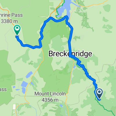
Seg12
A cycling route starting in Breckenridge, Colorado, United States.
Overview
About this route
- -:--
- Duration
- 48.1 km
- Distance
- 1,836 m
- Ascent
- 1,735 m
- Descent
- ---
- Avg. speed
- 3,820 m
- Max. altitude

Route quality
Waytypes & surfaces along the route
Waytypes
Path
32.7 km
(68 %)
Quiet road
2.9 km
(6 %)
Surfaces
Paved
12 km
(25 %)
Unpaved
35.6 km
(74 %)
Ground
33.2 km
(69 %)
Asphalt
11.1 km
(23 %)
Continue with Bikemap
Use, edit, or download this cycling route
You would like to ride Seg12 or customize it for your own trip? Here is what you can do with this Bikemap route:
Free features
- Save this route as favorite or in collections
- Copy & plan your own version of this route
- Sync your route with Garmin or Wahoo
Premium features
Free trial for 3 days, or one-time payment. More about Bikemap Premium.
- Navigate this route on iOS & Android
- Export a GPX / KML file of this route
- Create your custom printout (try it for free)
- Download this route for offline navigation
Discover more Premium features.
Get Bikemap PremiumFrom our community
Other popular routes starting in Breckenridge
 Fairplay - Frisco
- Distance
- 56.4 km
- Ascent
- 1,326 m
- Descent
- 1,273 m
- Location
- Breckenridge, Colorado, United States
 440 N Park Ave, Breckenridge to 435 N Park Ave, Breckenridge
- Distance
- 52 km
- Ascent
- 624 m
- Descent
- 619 m
- Location
- Breckenridge, Colorado, United States
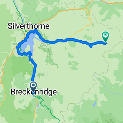
 Seg13
Seg13- Distance
- 54 km
- Ascent
- 1,393 m
- Descent
- 1,155 m
- Location
- Breckenridge, Colorado, United States
 hoosier
- Distance
- 64.9 km
- Ascent
- 592 m
- Descent
- 817 m
- Location
- Breckenridge, Colorado, United States
 Breckenridge - Keystone
- Distance
- 48.6 km
- Ascent
- 955 m
- Descent
- 635 m
- Location
- Breckenridge, Colorado, United States
 10 at 10 - middle portion
- Distance
- 37.6 km
- Ascent
- 854 m
- Descent
- 1,220 m
- Location
- Breckenridge, Colorado, United States
 Breck to A-Basin and back via the dam
- Distance
- 71.5 km
- Ascent
- 884 m
- Descent
- 886 m
- Location
- Breckenridge, Colorado, United States
 Summit Estates -> Highlands -> Boreas Loop
- Distance
- 43.6 km
- Ascent
- 869 m
- Descent
- 870 m
- Location
- Breckenridge, Colorado, United States
Open it in the app