
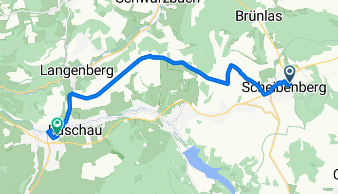
Klingerstraße 5, Scheibenberg nach Beethovenstraße 2, Raschau-Markersbach
A cycling route starting in Scheibenberg, Saxony, Germany.
Overview
About this route
- 31 min
- Duration
- 9.3 km
- Distance
- 29 m
- Ascent
- 269 m
- Descent
- 17.9 km/h
- Avg. speed
- ---
- Avg. speed
Route quality
Waytypes & surfaces along the route
Waytypes
Track
6.3 km
(68 %)
Road
1.4 km
(15 %)
Surfaces
Paved
9.2 km
(99 %)
Asphalt
8.9 km
(96 %)
Paved (undefined)
0.2 km
(2 %)
Undefined
0.1 km
(1 %)
Continue with Bikemap
Use, edit, or download this cycling route
You would like to ride Klingerstraße 5, Scheibenberg nach Beethovenstraße 2, Raschau-Markersbach or customize it for your own trip? Here is what you can do with this Bikemap route:
Free features
- Save this route as favorite or in collections
- Copy & plan your own version of this route
- Sync your route with Garmin or Wahoo
Premium features
Free trial for 3 days, or one-time payment. More about Bikemap Premium.
- Navigate this route on iOS & Android
- Export a GPX / KML file of this route
- Create your custom printout (try it for free)
- Download this route for offline navigation
Discover more Premium features.
Get Bikemap PremiumFrom our community
Other popular routes starting in Scheibenberg
 Fichtelberg und zurück
- Distance
- 37.1 km
- Ascent
- 841 m
- Descent
- 865 m
- Location
- Scheibenberg, Saxony, Germany
 Sonntagsrunde
- Distance
- 35.8 km
- Ascent
- 651 m
- Descent
- 651 m
- Location
- Scheibenberg, Saxony, Germany
 Radtour Rund um Scheibenberg
- Distance
- 6.3 km
- Ascent
- 91 m
- Descent
- 98 m
- Location
- Scheibenberg, Saxony, Germany
 Von Scheibenberg nach Dresden
- Distance
- 115.7 km
- Ascent
- 682 m
- Descent
- 1,223 m
- Location
- Scheibenberg, Saxony, Germany
 Scheibenberg-Fichtelberg-Scheibenberg
- Distance
- 45.9 km
- Ascent
- 1,071 m
- Descent
- 1,091 m
- Location
- Scheibenberg, Saxony, Germany
 Hemberg un zerück stoppen vergessen
- Distance
- 33.5 km
- Ascent
- 844 m
- Descent
- 872 m
- Location
- Scheibenberg, Saxony, Germany
 Zum Geyrischen Teich über den Mittelpunkt des Erzgebirgskreis
- Distance
- 35.3 km
- Ascent
- 593 m
- Descent
- 594 m
- Location
- Scheibenberg, Saxony, Germany
 Brünlastour
- Distance
- 8 km
- Ascent
- 115 m
- Descent
- 116 m
- Location
- Scheibenberg, Saxony, Germany
Open it in the app