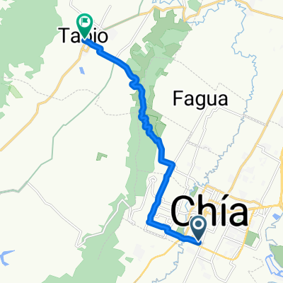
Ruta a Via A Tabio
A cycling route starting in ChÃa, Cundinamarca, Colombia.
Overview
About this route
- 5 h 37 min
- Duration
- 35.7 km
- Distance
- 964 m
- Ascent
- 963 m
- Descent
- 6.4 km/h
- Avg. speed
- ---
- Avg. speed
Route photos
Route quality
Waytypes & surfaces along the route
Waytypes
Road
22.5 km
(63 %)
Quiet road
12.8 km
(36 %)
Surfaces
Paved
4.1 km
(11 %)
Unpaved
26.6 km
(74 %)
Unpaved (undefined)
26.6 km
(74 %)
Paved (undefined)
2.3 km
(7 %)
Continue with Bikemap
Use, edit, or download this cycling route
You would like to ride Ruta a Via A Tabio or customize it for your own trip? Here is what you can do with this Bikemap route:
Free features
- Save this route as favorite or in collections
- Copy & plan your own version of this route
- Sync your route with Garmin or Wahoo
Premium features
Free trial for 3 days, or one-time payment. More about Bikemap Premium.
- Navigate this route on iOS & Android
- Export a GPX / KML file of this route
- Create your custom printout (try it for free)
- Download this route for offline navigation
Discover more Premium features.
Get Bikemap PremiumFrom our community
Other popular routes starting in ChÃa
- Chia Tabio Tenjo Chia Nivel 2
- Distance
- 31.7 km
- Ascent
- 361 m
- Descent
- 362 m
- Location
- ChÃa, Cundinamarca, Colombia
- Ruta a Via A Tabio
- Distance
- 35.7 km
- Ascent
- 964 m
- Descent
- 963 m
- Location
- ChÃa, Cundinamarca, Colombia
- De Via la Balsa a Via la Balsa
- Distance
- 21.2 km
- Ascent
- 182 m
- Descent
- 182 m
- Location
- ChÃa, Cundinamarca, Colombia
- vuelta al tominé
- Distance
- 100.9 km
- Ascent
- 433 m
- Descent
- 433 m
- Location
- ChÃa, Cundinamarca, Colombia
- Circuito Tenjo-Tabio-Chia
- Distance
- 33.6 km
- Ascent
- 361 m
- Descent
- 360 m
- Location
- ChÃa, Cundinamarca, Colombia
- cogua
- Distance
- 30.8 km
- Ascent
- 825 m
- Descent
- 753 m
- Location
- ChÃa, Cundinamarca, Colombia
- Alto Canicas
- Distance
- 41.2 km
- Ascent
- 849 m
- Descent
- 858 m
- Location
- ChÃa, Cundinamarca, Colombia
- De Carrera 5 Este #11-83, ChÃa a Carrera 5 Este # 11-83, ChÃa
- Distance
- 48.2 km
- Ascent
- 436 m
- Descent
- 430 m
- Location
- ChÃa, Cundinamarca, Colombia