
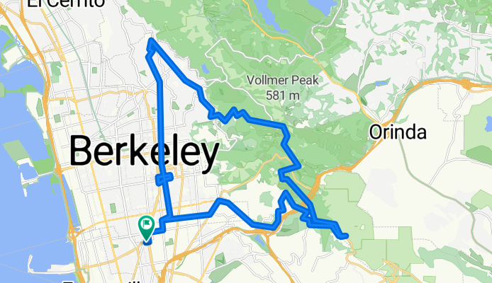
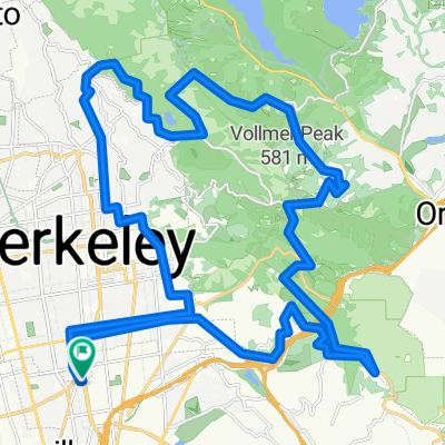
N Oakland - Tunnel Rd - Skyline - Grizzly Pk - Spruce - N Oakland CLONED FROM ROUTE 389894
A cycling route starting in Emeryville, California, United States.
Overview
About this route
2010.02.07 - rode with Jessica & Arielle
- -:--
- Duration
- 32.2 km
- Distance
- 568 m
- Ascent
- 568 m
- Descent
- ---
- Avg. speed
- ---
- Max. altitude
Route quality
Waytypes & surfaces along the route
Waytypes
Road
20.3 km
(63 %)
Quiet road
4.8 km
(15 %)
Surfaces
Paved
21.9 km
(68 %)
Asphalt
17.7 km
(55 %)
Paved (undefined)
3.2 km
(10 %)
Continue with Bikemap
Use, edit, or download this cycling route
You would like to ride N Oakland - Tunnel Rd - Skyline - Grizzly Pk - Spruce - N Oakland CLONED FROM ROUTE 389894 or customize it for your own trip? Here is what you can do with this Bikemap route:
Free features
- Save this route as favorite or in collections
- Copy & plan your own version of this route
- Sync your route with Garmin or Wahoo
Premium features
Free trial for 3 days, or one-time payment. More about Bikemap Premium.
- Navigate this route on iOS & Android
- Export a GPX / KML file of this route
- Create your custom printout (try it for free)
- Download this route for offline navigation
Discover more Premium features.
Get Bikemap PremiumFrom our community
Other popular routes starting in Emeryville
 Hill Loop
- Distance
- 40.1 km
- Ascent
- 691 m
- Descent
- 689 m
- Location
- Emeryville, California, United States
 Lake Merritt
- Distance
- 4.2 km
- Ascent
- 4 m
- Descent
- 4 m
- Location
- Emeryville, California, United States
 Three Bears Loop
- Distance
- 78.5 km
- Ascent
- 1,147 m
- Descent
- 1,147 m
- Location
- Emeryville, California, United States
 Christie Avenue 6363, Emeryville to San Francisco
- Distance
- 9 km
- Ascent
- 75 m
- Descent
- 57 m
- Location
- Emeryville, California, United States
 Park-Pinehurst Loop
- Distance
- 47.5 km
- Ascent
- 678 m
- Descent
- 676 m
- Location
- Emeryville, California, United States
 Bay Trail to Shoreline
- Distance
- 11.8 km
- Ascent
- 42 m
- Descent
- 45 m
- Location
- Emeryville, California, United States
 to angel island then Mandela co op
- Distance
- 21.1 km
- Ascent
- 169 m
- Descent
- 170 m
- Location
- Emeryville, California, United States
 evening mash
- Distance
- 38.3 km
- Ascent
- 3 m
- Descent
- 17 m
- Location
- Emeryville, California, United States
Open it in the app