

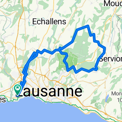
BRM 100 Mollendruz Marchairuz Signal de Bougy
A cycling route starting in Écublens, Canton of Vaud, Switzerland.
Overview
About this route
pour samedi si ça te tente...
- -:--
- Duration
- 100.7 km
- Distance
- 1,342 m
- Ascent
- 1,340 m
- Descent
- ---
- Avg. speed
- ---
- Max. altitude
Continue with Bikemap
Use, edit, or download this cycling route
You would like to ride BRM 100 Mollendruz Marchairuz Signal de Bougy or customize it for your own trip? Here is what you can do with this Bikemap route:
Free features
- Save this route as favorite or in collections
- Copy & plan your own version of this route
- Split it into stages to create a multi-day tour
- Sync your route with Garmin or Wahoo
Premium features
Free trial for 3 days, or one-time payment. More about Bikemap Premium.
- Navigate this route on iOS & Android
- Export a GPX / KML file of this route
- Create your custom printout (try it for free)
- Download this route for offline navigation
Discover more Premium features.
Get Bikemap PremiumFrom our community
Other popular routes starting in Écublens
 BRM 100 Mollendruz Marchairuz Signal de Bougy
- Distance
- 100.7 km
- Ascent
- 1,342 m
- Descent
- 1,340 m
- Location
- Écublens, Canton of Vaud, Switzerland
 Long Friday Track In St-Sulpice Vd
- Distance
- 15.1 km
- Ascent
- 39 m
- Descent
- 28 m
- Location
- Écublens, Canton of Vaud, Switzerland
 tour du lac plus halte a montreux
- Distance
- 192.3 km
- Ascent
- 550 m
- Descent
- 550 m
- Location
- Écublens, Canton of Vaud, Switzerland
 Porrentruy 2021 - Vendredi
- Distance
- 64.9 km
- Ascent
- 736 m
- Descent
- 737 m
- Location
- Écublens, Canton of Vaud, Switzerland
 Tour la Ecublens-La Sarraz
- Distance
- 56.7 km
- Ascent
- 686 m
- Descent
- 557 m
- Location
- Écublens, Canton of Vaud, Switzerland
 circuit viiiiite
- Distance
- 39.7 km
- Ascent
- 84 m
- Descent
- 329 m
- Location
- Écublens, Canton of Vaud, Switzerland
 Le Tour 2017 heen
- Distance
- 75 km
- Ascent
- 1,123 m
- Descent
- 373 m
- Location
- Écublens, Canton of Vaud, Switzerland
 Rushteam dimanche 4 avril
- Distance
- 84.2 km
- Ascent
- 599 m
- Descent
- 604 m
- Location
- Écublens, Canton of Vaud, Switzerland
Open it in the app