
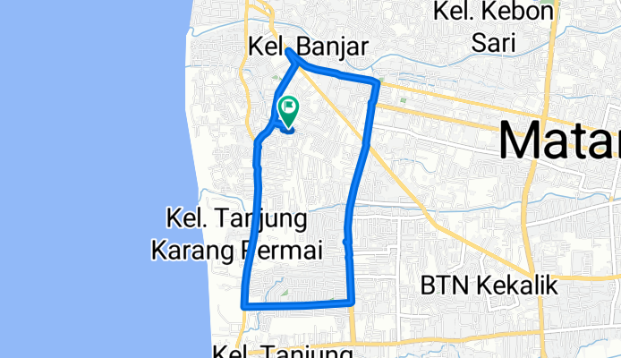
Jalan Gili Air 18, Kecamatan Ampenan to Jalan Gili Air 18, Kecamatan Ampenan
A cycling route starting in Mataram, West Nusa Tenggara, Indonesia.
Overview
About this route
- 37 min
- Duration
- 7.2 km
- Distance
- 134 m
- Ascent
- 118 m
- Descent
- 11.9 km/h
- Avg. speed
- ---
- Max. altitude

Route photos


Continue with Bikemap
Use, edit, or download this cycling route
You would like to ride Jalan Gili Air 18, Kecamatan Ampenan to Jalan Gili Air 18, Kecamatan Ampenan or customize it for your own trip? Here is what you can do with this Bikemap route:
Free features
- Save this route as favorite or in collections
- Copy & plan your own version of this route
- Sync your route with Garmin or Wahoo
Premium features
Free trial for 3 days, or one-time payment. More about Bikemap Premium.
- Navigate this route on iOS & Android
- Export a GPX / KML file of this route
- Create your custom printout (try it for free)
- Download this route for offline navigation
Discover more Premium features.
Get Bikemap PremiumFrom our community
Other popular routes starting in Mataram
 Day 10_Tue 31 Dec 13 - Mataram - Sanur
- Distance
- 128.7 km
- Ascent
- 119 m
- Descent
- 130 m
- Location
- Mataram, West Nusa Tenggara, Indonesia
 GPM BIKE COMMUNITY tour through Cakranegara Utara
- Distance
- 23.4 km
- Ascent
- 135 m
- Descent
- 136 m
- Location
- Mataram, West Nusa Tenggara, Indonesia
 saturday morning
- Distance
- 20 km
- Ascent
- 843 m
- Descent
- 854 m
- Location
- Mataram, West Nusa Tenggara, Indonesia
 Jalan Gili Air 16, Kecamatan Ampenan to Jalan Gili Air 18, Kecamatan Ampenan
- Distance
- 13.9 km
- Ascent
- 294 m
- Descent
- 294 m
- Location
- Mataram, West Nusa Tenggara, Indonesia
 Ride to Medas
- Distance
- 18.8 km
- Ascent
- 245 m
- Descent
- 224 m
- Location
- Mataram, West Nusa Tenggara, Indonesia
 Gowes Relax Mataram
- Distance
- 15.7 km
- Ascent
- 22 m
- Descent
- 23 m
- Location
- Mataram, West Nusa Tenggara, Indonesia
 TDC Telkomsel
- Distance
- 4.1 km
- Ascent
- 138 m
- Descent
- 134 m
- Location
- Mataram, West Nusa Tenggara, Indonesia
 Sesaot Tracking
- Distance
- 33.1 km
- Ascent
- 407 m
- Descent
- 149 m
- Location
- Mataram, West Nusa Tenggara, Indonesia
Open it in the app